
Deep within Mexico’s expansive wilderness, a remarkable ancient Mayan metropolis has been revealed—not through excavation, but through an extraordinary use of existing digital information. Despite being concealed for over a millennium, this city’s traces were quietly preserved in public online datasets for more than ten years.
Unveiling the Jungle’s Secret Through Data
The ancient settlement called Valeriana, located in Campeche, had been hidden beneath thick forest cover for centuries. Experts at Tulane University identified this ancient urban area by analyzing aerial images collected in 2013 under the Alianza M-REDD+ conservation initiative.
The findings, published on October 29 in the journal Antiquity, detail how researchers surveyed tens of square kilometers to uncover the impressive remains of Valeriana. This discovery has generated significant excitement in the archaeological community as an example of how serendipity and technology can combine to unlock the past.

An Enormous Ancient Mayan Urban Center
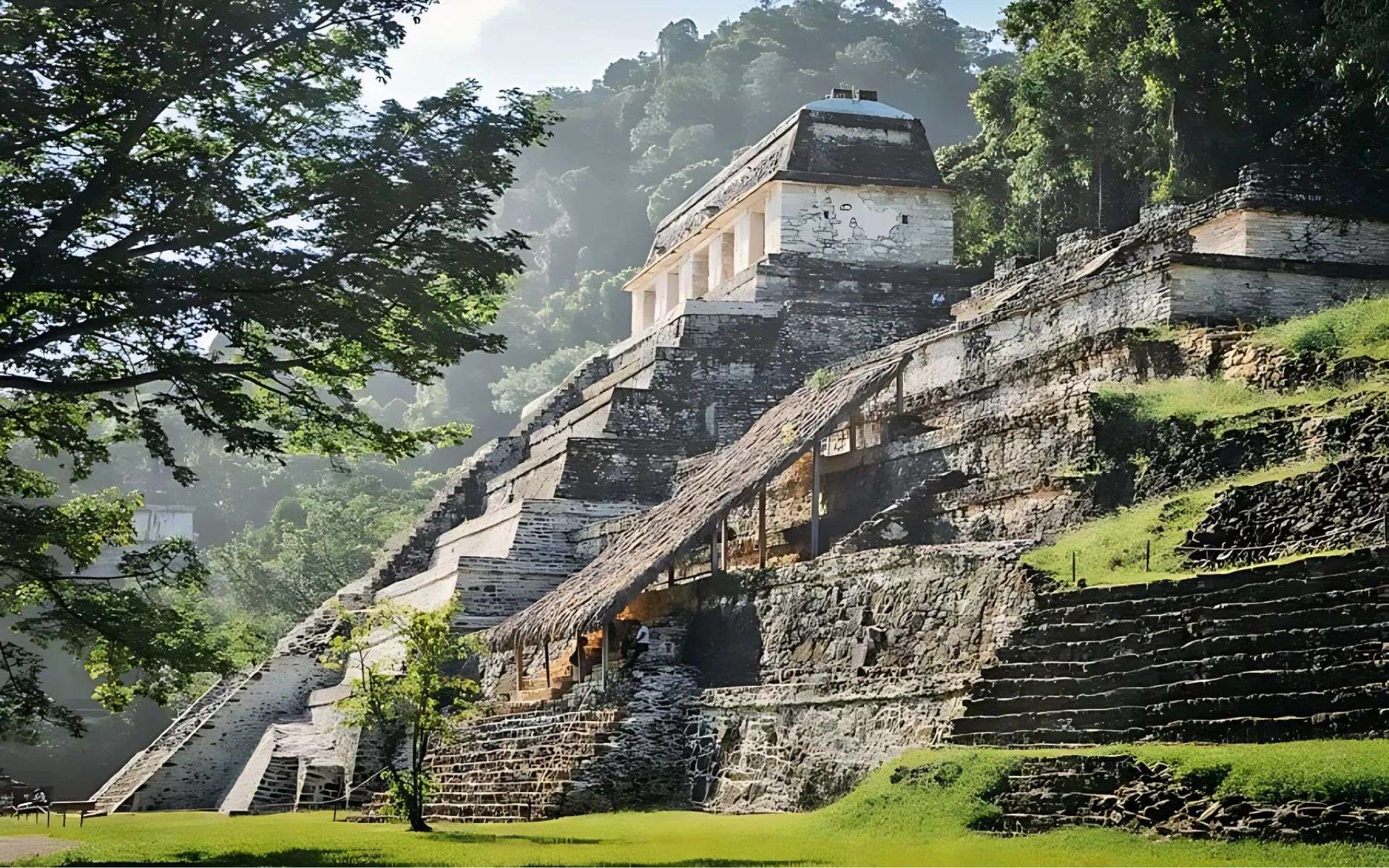
Valeriana represents far more than isolated ruins; it functioned as a vital religious and political center, likely supporting a population ranging from 30,000 to 50,000 people during the Maya Classic Period, between 250 and 900 CE.
The city’s sheer size includes grand temples, expansive infrastructure, and evidence of a flourishing society sustained over centuries.
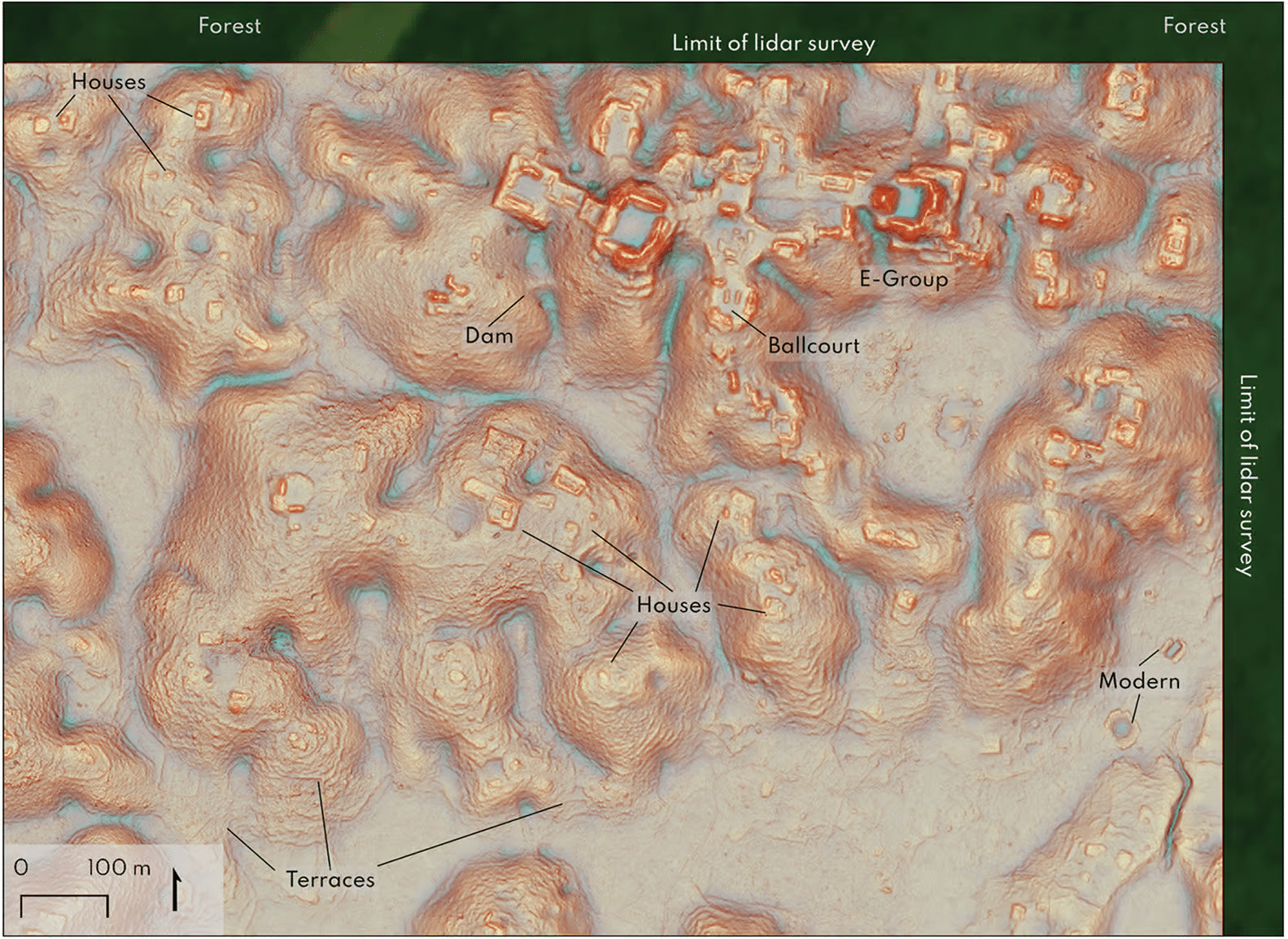
Through remote sensing, academics identified over six thousand structures across almost 122 square kilometers, showcasing the complexity and advanced social organization of its inhabitants.
Notable elements discovered include monumental pyramids and advanced water control systems. The site consists of two major urban zones spaced roughly two kilometers apart, with other important Maya centers like Chactun-Tamchen situated about twenty kilometers away.
The Rise of Collaborative Archaeological Exploration
What makes this breakthrough especially intriguing is how it exemplifies the impact of open-access scientific data in archaeology. The discovery relies on LiDAR (Light Detection and Ranging) technology, initially employed by the Alianza M-REDD+ project for mapping forested regions to support environmental protection.
LiDAR, despite its cost, has transformed archaeology by enabling researchers to peer through dense canopy that would otherwise block ground-based surveys. This laser scanning method creates precise elevation maps that reveal hidden human constructions.
Valeriana remained undetected until experts revisited these digital archives, demonstrating how public datasets from initiatives like NASA’s G-Liht and the European Space Agency’s aerial and satellite resources provide a wealth of untapped archaeological information. Vast collections of maps and raw data online present exciting opportunities for discovery to those equipped to analyze them.
Could the Next Discovery Be Yours?
The chance to reveal history’s mysteries no longer belongs exclusively to scientists. Thanks to open data, anyone with the right tools might identify new archaeological treasures.
With dedication and the appropriate software, new ancient settlements hidden beneath jungles or other landscapes might be uncovered from a computer screen rather than a excavation site. The example of Valeriana signals that many ancient American civilizations await rediscovery, and advancing technologies will only broaden our view into humanity’s rich past, leaving fewer mysteries hidden across the globe.


0 comments
Sign in to Comment