
Significant sections of Mexico City are dropping by over half an inch monthly, and a newly deployed radar satellite has precisely mapped the affected zones. Data unveiled on April 29 by NASA’s Jet Propulsion Laboratory highlights how the NISAR satellite is monitoring urban land subsidence with unprecedented detail in one of the globe’s most populous cities, overcoming challenges faced by earlier systems in densely populated or cloud-covered areas.
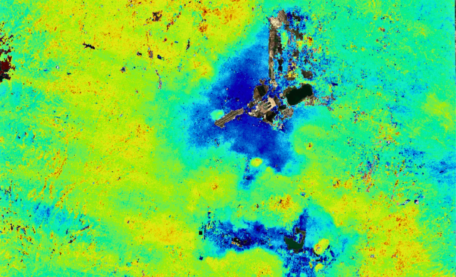
Measurements taken from October 2025 to January 2026, during Mexico City’s dry season, reveal areas of rapid sinking marked in dark blue within the published data, with some locations experiencing ground subsidence surpassing two centimeters monthly. Benito Juarez International Airport sits near the center, while Lake Nabor Carrillo appears northeast on the map.
A Century-Long Decline Accelerates
This issue has persisted for over a hundred years. Mexico City stands on a former lakebed that was drained, and persistent groundwater extraction combined with extensive urban development has compressed the underlying soft sediments over generations. The first documentation of the city’s sinking dates back to 1925 by an engineer.

By the late 20th century, parts of the city were subsiding about 35 centimeters per year, enough to cause structural damage such as cracks in metro tunnels, warped roads, and broken water pipes throughout the metropolitan area. These effects are far from superficial, continually weakening vital infrastructure serving millions daily, with no natural restoration once the sediment compresses.
The Angel of Independence monument on Paseo de la Reforma visually illustrates this phenomenon. Erected in 1910 for Mexico’s centennial, it was originally level with the street, but now rests 14 steps above as the surrounding ground has lowered. The monument remains stable; the city itself has shifted.
What Sets NISAR Apart from Previous Satellites
Earlier radar satellites have tracked Mexico City’s sinking but faced constraints. Environmental factors like cloud cover, thick vegetation, and night conditions impair optical and higher-frequency radars. NISAR’s L-band radar, operating at a 24-centimeter wavelength, penetrates these conditions without losing signal fidelity.
Additionally, NISAR carries an S-band instrument operating at 9.4 centimeters, marking it as the first satellite equipped with dual-frequency synthetic aperture radar. Together, these sensors enhance the ability to distinguish true ground movements from atmospheric disturbances, raising measurement reliability especially in complex regions where a single sensor might falter.

NISAR revisits the same ground point every 12 days, allowing consistent tracking that detects shifts down to millimeters. NASA’s deputy project manager Craig Ferguson highlighted the accuracy of the Mexico City maps, emphasizing the L-band radar’s importance for coastal zones where subsidence combines with rising sea levels, increasing flood risks in ways previously difficult to assess.
Engineered for Longevity and Broad Impact
Launched from India’s Satish Dhawan Space Centre on July 30, 2025, the NISAR mission represents collaboration between NASA and the Indian Space Research Organisation. NASA’s Jet Propulsion Laboratory developed the L-band radar and antenna, while ISRO provided the spacecraft and the S-band instrument.
Its most distinctive feature is the 12-meter wide drum-shaped antenna reflector, the largest radar antenna ever deployed in orbit, enabling enhanced signal reception. This broad reflector enables finer measurement resolution across extensive urban areas, crucial for detecting subtle movements spanning whole cities.
Orbiting at 464 miles altitude, NISAR is actively gathering scientific data. By late February 2026, over 100,000 datasets were publicly released through the Alaska Satellite Facility, supporting not just NASA researchers but also government bodies, urban planners, and disaster response groups worldwide requiring dependable ground-motion information.
Interpreting the Data and Future Prospects
Current Mexico City imagery is preliminary. JPL explains that yellow and red features likely represent noise artifacts expected to reduce with continued observations and a strengthening baseline. Conversely, the dark blue zones of subsidence align closely with historical measurements and known sediment compaction behavior.
David Bekaert from the Flemish Institute for Technological Research and a NISAR science team member described Mexico City as a pilot case demonstrating the satellite’s global potential. “Mexico City is a recognized hotspot for subsidence, and this imagery marks just the start of NISAR's contributions,” he stated. “We anticipate many new insights worldwide due to NISAR’s unique sensing and steady global coverage.”
Data from NISAR is freely accessible through the Alaska Satellite Facility DAAC. Subsequent dry seasons will offer comparable datasets, enabling researchers to monitor year-to-year changes in Mexico City’s sinking lakebed and evaluate impacts of shifts in water use or urban development overhead.
- Categories:
- News


0 comments
Sign in to Comment