

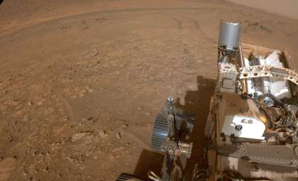
NASA’s Perseverance rover has traversed a significant geological landmark located southeast of Jezero Crater—Soroya Ridge. This pale, prominent outcrop captured scientists’ interest ever since it was first observed in high-resolution orbital imagery. A recently released image shows the rover positioned atop the ridge. Yet, as detailed in NASA's article "Over Soroya Ridge & Onward!", the scientific implications behind this photo extend far beyond the striking vista.
Why Soroya Ridge Was a Standout Feature from Space
Long before Perseverance reached Mars, researchers had noticed Soroya Ridge through detailed orbital scans. The light-hued ridge stood out in sharp contrast to the darker terrain around Jezero’s southeast flank, hinting at a unique geological history—possibly influenced by ancient water activity or rock alteration processes. When the rover neared the site last week, this distinctive formation was clearly visible, even from ground-level camera views.
Mission planners designated the formation as Soroya Ridge and navigated the rover from its previous stop at Parnasset, where studies on wind-shaped bedforms had been conducted. Following three strategic driving segments, Perseverance reached Soroya, a well-suited "workspace" providing stable, flat bedrock ideal for thorough in-depth analysis. This path highlights the mission's careful planning to maximize scientific discovery at every location.

Detailed Surface Analysis at Soroya
Upon arrival, Perseverance deployed an array of sophisticated instruments to uncover the geological story of the ridge. Using the WATSON and SHERLOC ACI imaging tools, researchers examined the rock surfaces closely, studying textures, fissures, and weathering details to identify sediment layers or mineral formations indicative of past water presence.
For chemical profiling, the rover employed SCAM LIBS, ZCAM multispectral cameras, and PIXL. SCAM LIBS (SuperCam Laser-Induced Breakdown Spectroscopy) analyzes elements by firing a laser at rocks and assessing the emitted light, while PIXL creates detailed elemental maps of dust-cleared rock sections. Together, these instruments build a comprehensive chemical portrait of Soroya Ridge.
Environmental measurements continued with MEDA monitoring prevailing weather, and ZCAM’s panoramic imaging helped plan upcoming exploration routes. Each instrument's data contributes to a coordinated campaign to assess this site’s potential for astrobiology.
Significance of Soroya Within Mars Exploration
Soroya Ridge is crucial because it fits into the mission’s broader goal of searching for traces of ancient life on Mars. Since 2021, Perseverance has explored Jezero Crater, a once water-filled basin that may contain preserved biosignatures. The ridge’s distinct coloration and height raise the prospect of finding minerals formed or altered by water, making it a prime scientific target.
Additionally, Soroya’s accessible and flat geology strengthens its candidacy for sample collection and caching, supporting the eventual Mars Sample Return endeavor. Though the future of that mission faces uncertainties, each core collected at sites like Soroya adds invaluable material to planetary science archives.
Ultimately, Soroya Ridge serves as a vital link in a comprehensive search spanning millions of miles, thousands of Martian days, and decades of exploration planning.
Looking Ahead: Perseverance’s Upcoming Moves
The rover’s next targets will be chosen based on detailed surveys by ZCAM of the terrain surrounding Soroya Ridge. The science team is carefully evaluating potential sites that promise rich discoveries while considering rover durability, power usage, and mission timelines.
As Perseverance continues its journey, every Martian sol is another step forward in unraveling the Red Planet’s mysteries. While Soroya Ridge now lies behind, insights gained there may revolutionize our understanding of Mars for years ahead.
- Categories:
- News


0 comments
Sign in to Comment