

The National Hurricane Center (NHC) is closely observing an evolving weather system in the Atlantic that may pose risks to Florida.
This disturbance currently faces a 40% probability of developing into a named tropical storm, which would be called “Chris” if it reaches that classification.
The system is originating as a tropical wave advancing across the Leeward Islands and the Greater Antilles, key regions that often help forecast storm trajectories toward the southeastern U.S.

The latest NHC briefing stresses increasingly favorable conditions for the system to intensify into a tropical depression by mid to late week, possibly impacting Florida and nearby areas significantly.
Present Weather Scenario
The disturbance currently consists of a zone of unsettled weather interacting with an approaching tropical wave. This interaction is critical as it may strengthen the system’s organization, increasing chances of it developing into a tropical depression or a named storm.
Per the NHC’s Tropical Weather Outlook, the formation likelihood is low within the next 48 hours but rises to a medium probability over the coming week.
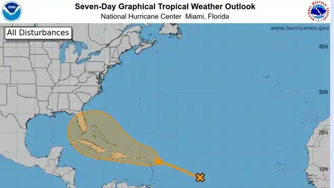
The potential development area spans from the northern Leeward Islands reaching into the southwestern Atlantic, a zone currently influenced by Saharan dust.
While Saharan dust commonly suppresses storm growth by drying the air, present atmospheric moisture may be sufficient to offset this, supporting potential cyclone formation.
Forecasted Impact and Trajectory
This system's future path remains uncertain, with possibilities including movement east of Florida, entry into the Gulf of Mexico, or dissipation over Caribbean highlands.
The Saharan dust presence adds complexity; it typically hampers storm development by introducing dry air, but regions with elevated moisture might foster strengthening.
If the disturbance evolves into a tropical storm, affected areas could see heavy rainfall, gusty winds, and hazardous weather, making it essential for local communities and officials to stay alert and prepare accordingly.
Outlook for the Season
This potential storm forms after a quiet start to the 2024 hurricane season, yet experts warn this lull could be temporary as the season is projected to be more active than usual.
The recent rapid development of Hurricane Beryl, the earliest Category 5 Atlantic hurricane on record, has heightened vigilance.
Beryl’s swift intensification and record-breaking eastern formation in June have raised concerns among forecasters about increased odds of major hurricane impacts along the U.S. coastline and the Caribbean.
Colorado State University has revised its forecast upward to 25 named storms this season, up from the initial 23, reflecting warm ocean temperatures and other favorable atmospheric factors fueling storm potential.
Experts advise residents in susceptible regions to stay alert and ready for a potentially demanding hurricane season. The combination of warm seas and supportive wind conditions primes the Atlantic basin for heightened storm activity.
The NHC along with other meteorological agencies will continue monitoring the system closely, issuing updates and alerts as circumstances evolve. Given the possibility of fast strengthening, like that seen with Hurricane Beryl, preparedness plans and regular information checks via official sources are highly recommended.
- Categories:
- News ,
- Climate change


0 comments
Sign in to Comment