
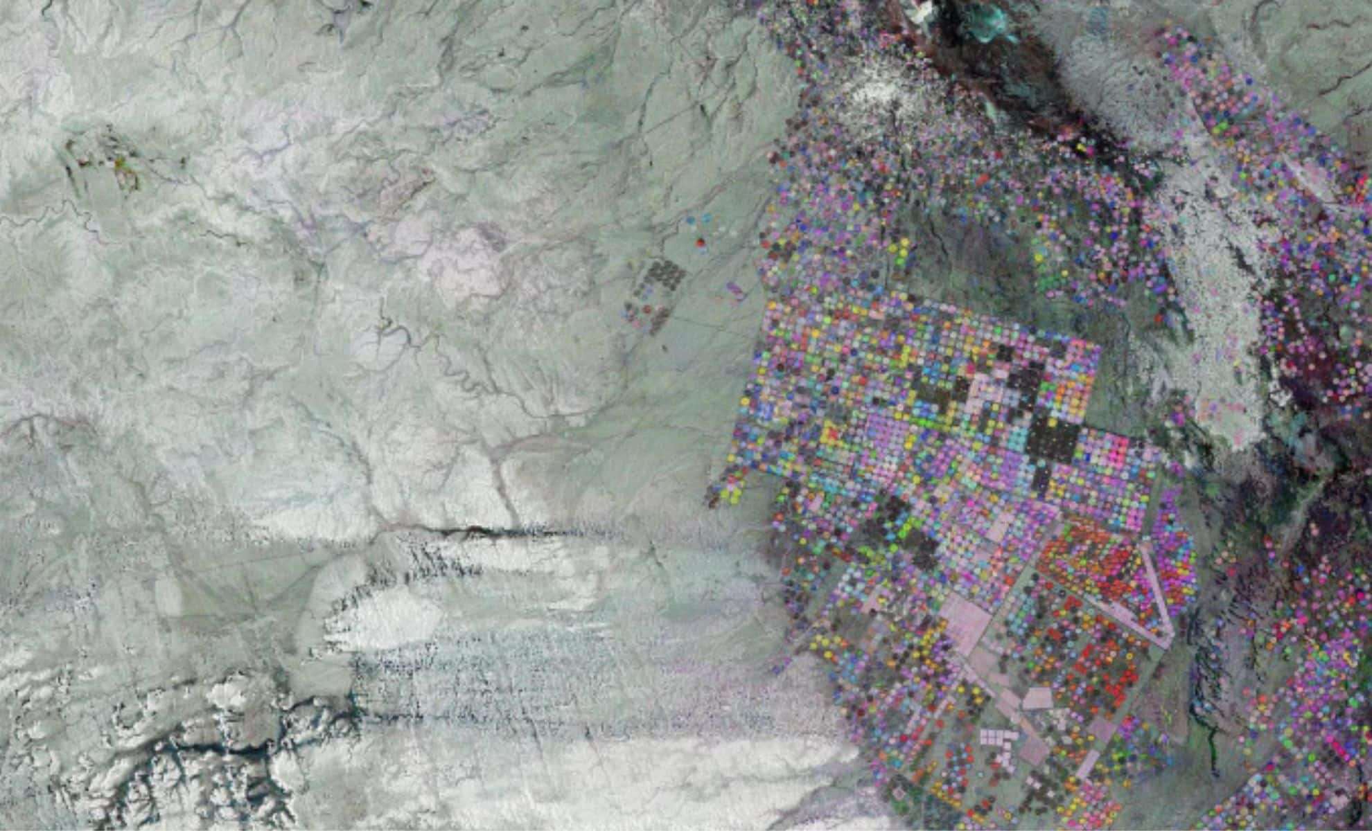
A recent image released by the European Space Agency (ESA) reveals intriguing circular farming patterns set amidst the arid expanse of Saudi Arabia’s desert terrain. Captured using the Copernicus Sentinel-1 satellite system, these circular fields illustrate a cutting-edge irrigation method crucial for cultivating crops in one of the driest regions on Earth. This visual highlights how advanced technology paired with efficient water resource management is reshaping northern Saudi Arabia’s landscape, enabling sustainable agriculture in otherwise inhospitable environments.
Far beyond a mere visual, this satellite snapshot demonstrates human resourcefulness in tackling severe drought conditions. By tapping into subterranean aquifers, these irrigation circles help sustain agricultural productivity, bolster local economies, and improve food security. Studying such techniques is increasingly important amid worldwide water shortages driven by climate change. This space-based data plays a key role in assessing the health and sustainability of agricultural expansion in fragile desert ecosystems.
The Science of Circular Irrigation Systems
Central to this agricultural feat is the deployment of central-pivot irrigation technology. Water is extracted from deep wells and delivered to rotating sprinkler systems that irrigate the large circular plots visible in the ESA’s satellite photo. Each circle spans about a kilometer in diameter, designed to maximize efficient water use across vast tracts of desert farmland. These geometric patterns aren’t just visually striking but represent a strategic solution to severe water constraints, allowing precise water application and conservation.

Given the erratic and minimal rainfall Saudi Arabia experiences, traditional farming methods are unworkable. Reliance on finite underground water reserves makes their sustainable use essential to future farming viability. The pivot irrigation system supports farmers in controlling irrigation volumes carefully, minimizing waste while optimizing crop yield. This technology has been instrumental in transforming desert patches into fertile grounds capable of producing essential food crops for domestic and export markets.
Sentinel-1’s Role in Environmental Surveillance
The stunning image owes its detail to the Copernicus Sentinel-1 satellite, a key instrument in Europe’s Earth observation endeavor aimed at tracking land use and environmental dynamics. Over seven months, the satellite collected radar images which were blended into a composite, with individual captures from October 2024, January 2025, and May 2025 mapped to blue, green, and red shades. This color layering technique reveals variations in vegetation health, irrigation patterns, and land status.
Through these colors, observers can distinguish stages of crop development and identify zones of stability or change. Whites, grays, or blacks correspond to bare soil, fallow fields, or desert surfaces where growth is limited. The satellite’s data stream delivers actionable insights for agriculturists and environmental managers, enabling them to monitor crop vitality, water allocation, and the environmental footprint of expanding agriculture in the desert.
Transforming Saudi Desert into Cultivable Land
The agricultural landscape of Saudi Arabia is shaped by extreme heat and scarce freshwater supplies. Despite these obstacles, large sections of northern desert, such as those captured in the ESA imagery, have been converted into productive farmlands thanks to innovative irrigation technologies. Besides central-pivot systems, the kingdom also integrates drip irrigation and, in some locations, treated wastewater reuse to increase water efficiency.
The Wadi As Sirhan basin, featured prominently in the image, exemplifies how desert environments can be leveraged for farming. Seasonal rains temporarily fill natural basin areas, which combined with irrigation infrastructure, sustain a range of crops. This agricultural practice not only addresses local food demand but also contributes vital economic support to neighboring settlements. The broader shift towards scalable farming in desert zones is diversifying Saudi Arabia’s economy by reducing its exclusive dependence on oil revenue.
Tabarjal: The Agricultural Keystone of Northern Saudi
Within the image’s network of circles lies the town of Tabarjal, visible near the upper right. This relatively small desert town plays a crucial role due to the surrounding agriculture. Tabarjal functions as a pivotal economic and logistical nucleus, supporting rural farming communities. The local crops underpin food supplies and bolster trade activities, positioning the town as a vital hub in the arid northern region.
With agriculture gaining prominence, Tabarjal’s importance is mounting in Saudi Arabia’s broader shift away from fossil fuel reliance toward resource diversification. Monitoring agricultural expansion through satellite imagery offers critical understanding of how such socio-economic transformations are unfolding in these challenging desert landscapes.
- Categories:
- News


0 comments
Sign in to Comment