
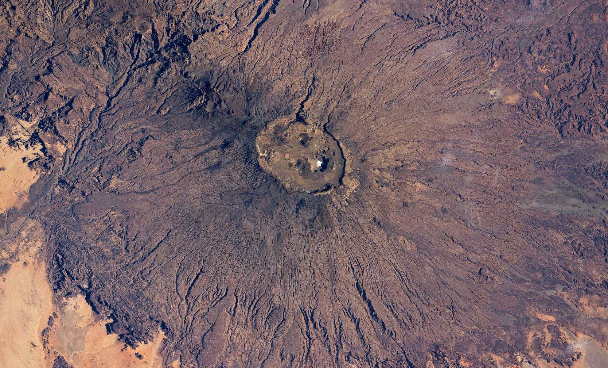
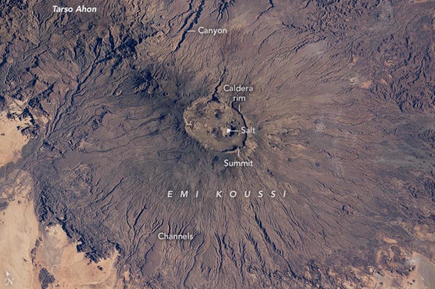
Recently, astronauts aboard the International Space Station captured a striking image of the summit of Emi Koussi, the tallest volcano in the Sahara Desert located in northern Chad. At first glance, a bright white spot at the peak might be mistaken for snow, but it is actually the dried residue of a small lake encrusted with salt. Emi Koussi reaches an altitude of 3,415 meters (11,204 feet), dominating its harsh desert surroundings.
This remarkable photo presents Emi Koussi’s immense volcanic cone, which spans approximately 70 kilometers in diameter. Situated amidst the Sahara’s extreme environment, the white area belongs to the volcano’s caldera, found at its lowest point nearly 745 meters beneath the peak.
Salt Lake: A Window into Sahara’s Wetter Past
The white formation atop Emi Koussi stems from a salt-covered, dried-up lake bed nestled inside the caldera. The salt layer gives it a stark white appearance, a remnant of when water once filled this depression. The NASA Earth Observatory explains that this vanished lake offers clues about the ancient climate of the Sahara, indicating a time when rainfall was more abundant than it is today’s hyper-arid conditions.

Thanks to the high-resolution satellite imagery, features such as the dried lake and volcanic fumaroles—small circular vents—are visible within the caldera. These details highlight an ongoing volcanic history, supported by geological evidence that the Sahara’s climate and landscape have shifted dramatically over time.
Evidence of Past Water Flow Carved into Volcanic Terrain
Beyond the whitened lake bed, the image depicts numerous narrow erosion channels, marking ancient paths taken by water gently carving the volcano’s surface. Despite minimal rainfall in the region today, geologists suggest these features formed over millennia through intermittent streams and runoff, revealing evidence of a wetter past. Dry riverbeds seen in the area further establish this narrative of changing precipitation patterns across the Sahara.
The volcanic mountains Emi Koussi and nearby Tarso Ahon are linked by deep canyons sculpted from water runoff. These natural formations act as geological records of vanished watercourses, underscoring the critical influence water once exerted on shaping this desert’s landscape.
Beyond Endless Sands: Exploring Sahara’s Geological Narratives
This awe-inspiring image of Emi Koussi challenges the conventional view of the Sahara as merely a sandy wasteland. Instead, it reveals a complex terrain shaped by volcanic activity and intermittent water presence in the past. The salt-crusted lake bed and water-eroded channels collectively tell a story of a dynamic environment with a rich geological heritage.
Although today’s Sahara is arid and mostly barren, its geological features—from volcanic peaks to dry lake beds—preserve invaluable evidence about Earth’s climatic history and the transformative processes that created one of the world’s most iconic deserts.
- Categories:
- News


0 comments
Sign in to Comment