
A groundbreaking study led by NASA has identified a concealed hazard aggravating the rise of sea levels along global coastlines. While climate change and glacier melt have been recognized as primary contributors, the movement of the land itself—with some areas sinking more rapidly than the seas are climbing—is intensifying risks. Utilizing satellite observations, scientists have located regions where the ground is subsiding at alarming speeds, threatening to flood coastal urban centers much sooner than anticipated. This revelation demands an urgent revision of sea level forecasts, with some zones facing twice the rise previously predicted by 2050.
Unearthing the Ground’s Unseen Shifts
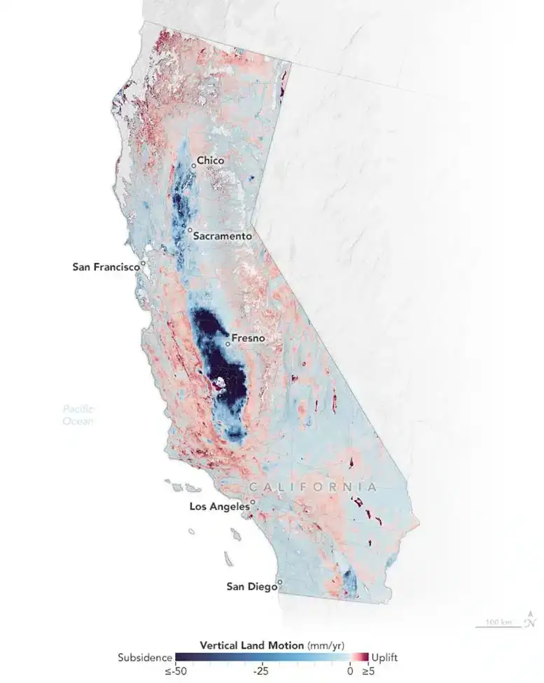
Published on January 29, 2025, in Science Advances, this research led by Marin Govorcin from NASA’s Jet Propulsion Laboratory (JPL) explores how vertical land motion—the lowering and rising of Earth's surface—impacts regional sea level estimations. The study harnessed interferometric synthetic aperture radar (InSAR) technology aboard ESA’s Sentinel-1 satellites to monitor elevation changes along California's coastline from 2015 through 2023.
The results reveal a worrying pattern: numerous locations are sinking at rates greater than 0.4 inches (10 mm) annually, exacerbating the effects of sea level rise. In areas such as the San Francisco Bay, where ground compression is significant, local sea level increases could reach over 17 inches (45 cm) by mid-century—more than double earlier estimates that considered only oceanic rise. This underscores the urgency of including land subsidence in future flood risk assessments.

Human Actions Driving Accelerated Subsidence in Coastal Zones
While natural tectonic activity contributes to sinking land, human influence plays a substantial role in accelerating subsidence. Activities such as excessive groundwater pumping, extraction of oil and gas, and urban development are hastening ground compaction beyond natural levels.
“In certain areas, including reclaimed sections of San Francisco, the ground is descending faster than sea levels are elevating,” states Marin Govorcin. This means infrastructure designed with older sea level estimates may already fall short, leaving cities exposed to flooding much earlier than planned.
The study also identified localized land uplift zones, where the ground is rising rather than sinking. Regions like Santa Barbara and Long Beach experience this due to groundwater replenishment and fluid injections linked to oil extraction. Nevertheless, these uplift incidents occur sporadically, posing challenges for integration into broader climate prediction models.
California’s Shoreline: Examining Vulnerability
By analyzing land dynamics across more than 1,000 miles of California's coast, NASA combined forces with NOAA to map high-risk locations where subsidence worsens rising sea levels. The San Francisco Bay area ranks among the most at risk, especially in low-lying communities like San Rafael, Corte Madera, Foster City, and Bay Farm Island, where ground descent exceeds 0.4 inches annually.
Earlier projections, which considered only oceanic changes, underestimated these dangers. If trends persist, flood events once expected far in the future might occur within just a few decades. Similar concerns exist for cities like Los Angeles and San Diego, where hydrocarbon extraction and other human activities introduce uncertainty into predictions.
Hidden Hazards in Aquifers and Coastal Slopes
Beyond urban areas, California's Central Valley endures some of the fastest land sinking in the state. Ground in sections of the valley is descending by up to 8 inches (20 cm) annually, mainly due to drought-driven excessive groundwater withdrawal. As underground water sources dwindle, the overlying ground compacts, causing permanent subsidence that compounds sea level rise impacts.
Scientists have additionally tracked slow-moving landslides along California’s rugged coasts, especially in Big Sur and the Palos Verdes Peninsula. These shifts create local zones of subsidence, destabilizing communities along the shoreline. Northern California marshlands and lagoons near San Francisco and Monterey Bays, vital as natural flood shields, are also experiencing erosion-related sinking.
Satellite Surveillance: Tracking Earth’s Movement to Save Cities
Accurately tracing land motion has become vital for projecting the realistic effects of sea level rise. NASA’s OPERA (Observational Products for End-Users from Remote Sensing Analysis) initiative employs satellite data to monitor elevation changes across North America, aiding policymakers and urban planners in boosting coastal resilience.
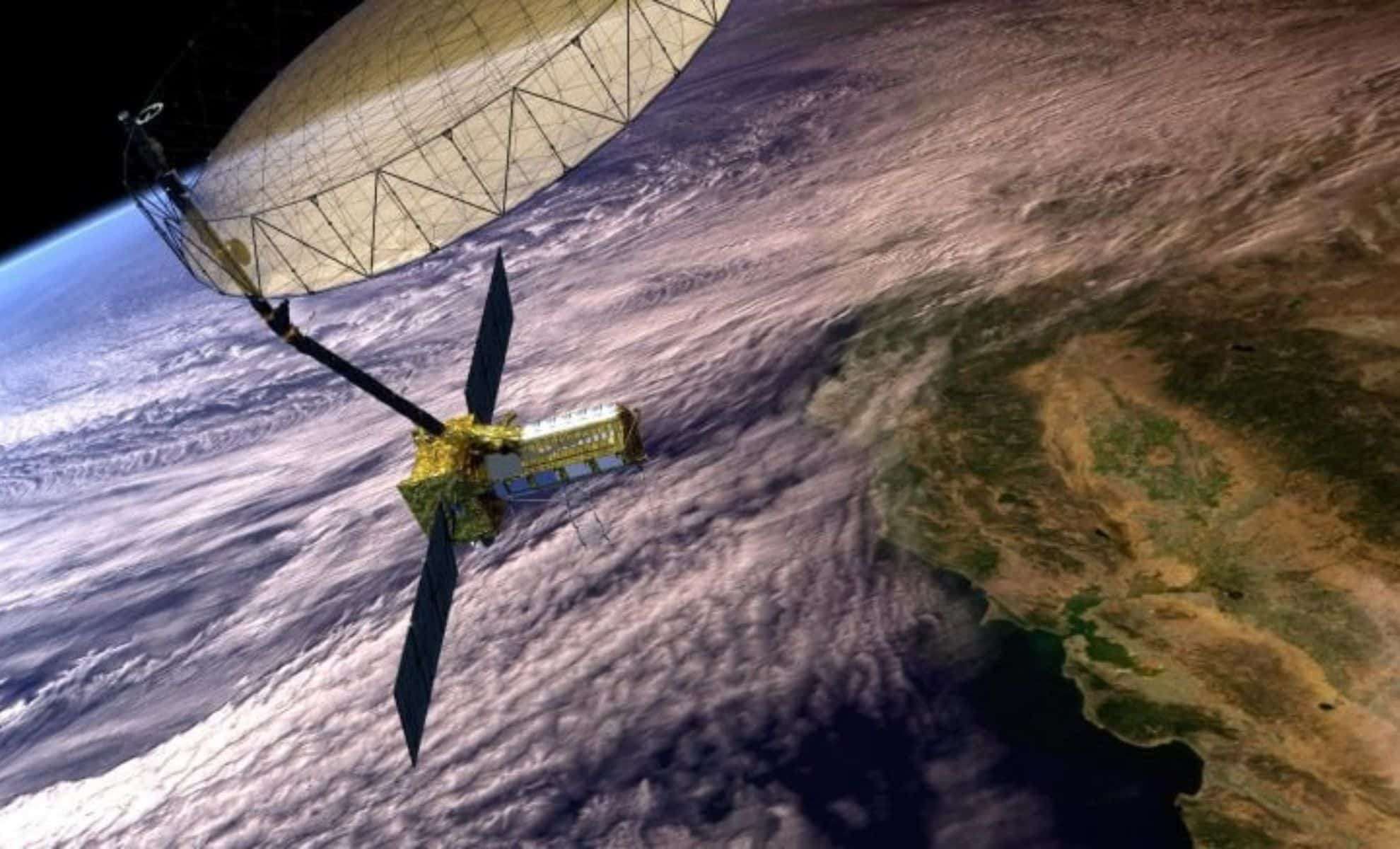
The forthcoming NASA-ISRO Synthetic Aperture Radar (NISAR) mission, a collaborative project with India’s space agency, will provide enhanced global monitoring with near-real-time, fine-resolution land motion data. This technology promises to forecast potential subsidence hotspots, mitigating damages and saving lives by anticipating threats to infrastructure well in advance.
- Categories:
- News


0 comments
Sign in to Comment