
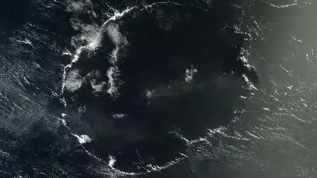
NASA’s Terra satellite recently captured an extraordinary and nearly perfect circular cloud formation isolated in the heart of the Pacific Ocean. This massive ring of cumulus clouds offers a rare glimpse into atmospheric processes, representing one of the most remarkable natural convection patterns ever documented from orbit. Though the formation dates back to 2014 satellite data, it has only recently gained attention for its unique and striking appearance.
Located thousands of kilometers southwest from the Hawaiian Islands, this impressive ring spans approximately 280 miles across. While circular cloud patterns occasionally occur, seeing such a well-defined and solitary ring over open water is exceptionally uncommon. This finding enriches our understanding of upper-atmosphere phenomena and highlights the complex behavior of weather systems in remote oceanic environments.
Convection Creates a 280-Mile Circular Cloud Formation
The striking image, captured by NASA’s MODIS instrument aboard the Terra satellite, illustrates a classic Rayleigh-Bénard convection cell—a weather event driven by warm air rising and cooler air descending. These dynamic atmospheric cells frequently generate cloud patterns shaped by temperature-driven air circulation.

In this scenario, a closed-cell cloud pattern appeared, characterized by dense cloud cover in the center surrounded by clearer skies at the edges. Unlike their open-cell counterparts, which resemble delicate honeycombs, closed-cell clouds are thicker and infrequently observed in such pristine, isolated conditions.
Uncommon Single Cloud Cell Stands Apart in the Sky
The distinctive feature of this cloud ring is its isolated presence. Normally, convection cells develop in groups, forming a repeating atmospheric mosaic. The emergence of a single, isolated convection cell indicates that highly localized conditions prompted this rare event.
As detailed by NASA’s Earth Observatory, a probable cause was an area of superheated ocean surface or a small heated landmass. Warm air ascending from this patch formed cumulus clouds that produced light rain. The evaporation cooled nearby air, which descended and moved outward. Upon encountering warmer air, this cooler air forced upward movement, generating a circular updraft responsible for the iconic cloud ring.
Subtle Role of the Intertropical Convergence Zone
This rare cloud ring appeared just south of the Intertropical Convergence Zone (ITCZ), a region near the equator known for persistent storms and heavy rainfall. The ITCZ may have influenced the environmental conditions by supplying moisture and fostering vertical atmospheric instability necessary for the cell’s formation.
Enhancing the scene’s surreal beauty, sunlight reflected off the ocean produced a sunglint effect east of the cloud pattern, turning the water’s surface into a shimmering, molten silver mirror. This optical phenomenon only happens when the sun’s position aligns perfectly with the satellite’s viewing angle, intensifying the photograph’s dramatic visual appeal.
Recognizing Cloud Cells Became Possible with Satellite Technology
Cloud convection cells were first identified after the launch of NASA’s pioneering weather satellite TIROS-1 in 1961. Before satellites, researchers had limited understanding of the geometric and organized nature of cloud systems from a top-down view.
Today, decades of remote sensing offer critical insights into atmospheric dynamics that remain unseen at ground level. Observations of formations like this help improve weather forecasting and advance scientific models related to convection, precipitation, and interactions between the ocean and atmosphere.
- Categories:
- News


0 comments
Sign in to Comment