
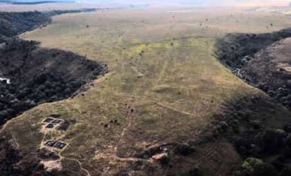
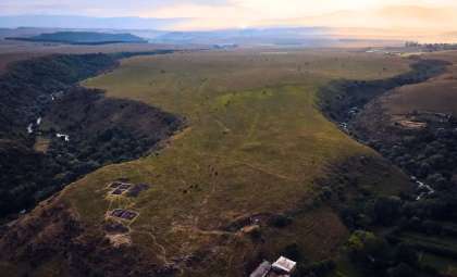
Archaeologists have revealed a 5,000-year-old ancient fortress concealed within the dense woods of Neamț County, Romania. This remarkable construction dates back to the shift between the Neolithic and Bronze Ages, offering valuable insights into early human settlements.
Thick vegetation had completely masked this prehistoric stronghold, which only came to light through advanced LiDAR (Light Detection and Ranging) technology. This innovative approach is transforming archaeological exploration, as demonstrated by this extraordinary finding.
LiDAR Brings Hidden Ruins Into View
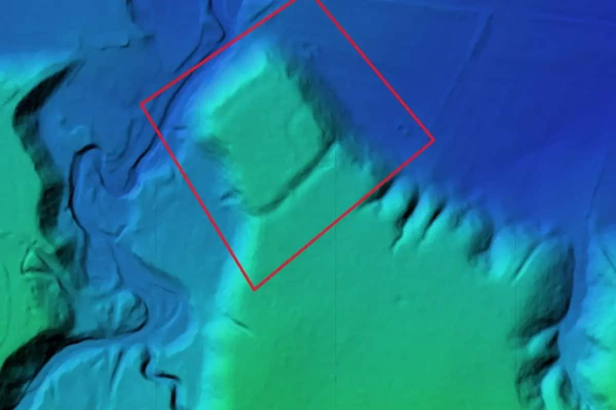
LiDAR technology employs laser pulses to generate detailed maps of terrains obscured by dense plant growth. Researchers utilized drones outfitted with LiDAR equipment to scan the aerial landscape, revealing the fortress’s outline and its environment.

Previously, uncovering such sites required laborious soil excavation and clearing of vegetation before any visible traces could be identified. LiDAR revolutionizes this process by “scanning” the terrain with precise laser beams and timing their return to the sensor, uncovering hidden structures in the otherwise impenetrable landscape. Archaeologist Vasile Diaconu, part of the discovery team, stated:
“Thanks to current technology and using LiDAR scans I was able to obtain a faithful image of an almost 5000-year-old fortification.” He added in a Facebook post, “On this occasion, we observed details that we could not observe in the field precisely because of the vegetation.”
Strategic Design and Placement
The fortification showcases deliberate architectural planning and defense strategy. Situated on elevated terrain, it would have permitted clear observation of the surrounding landscape, enabling residents to detect approaching dangers early. The site’s position reflects a calculated choice for maximizing defensive potential. Diaconu remarked:
“most of the fortified sites were located in high areas, which had good visibility and were reinforced by ditches and even earthen mounds in order to increase their defensive capacity.”
LiDAR images revealed that the fortress was fortified with ditches and large earthen embankments extending across several hundred meters, representing a significant workforce and considerable construction effort.
This extensive labor investment indicates a well-organized community rather than a transient group simply trying to survive day-to-day.
Collaboration Drives Discovery
The excavation emerged from a joint effort between Geocad Services, Geo Edu Lab, and the National Institute for Research and Development for Earth Physics. An intriguing element was the teamwork between a teacher and his former student: Vlad Dulgheriu, now leading Geocad Services, contacted his former professor Vasile Diaconu to spearhead this discovery.
Diaconu expressed how meaningful it was to partner with his protégé, whose enterprise provided the essential LiDAR technology for mapping the ancient site.
“I’m honestly glad my former student has built his own road beautifully.”he noted, “Only by using modern technologies will we be able to better understand the complexities of archaeological sites,” he stated.
- Categories:
- News


0 comments
Sign in to Comment