
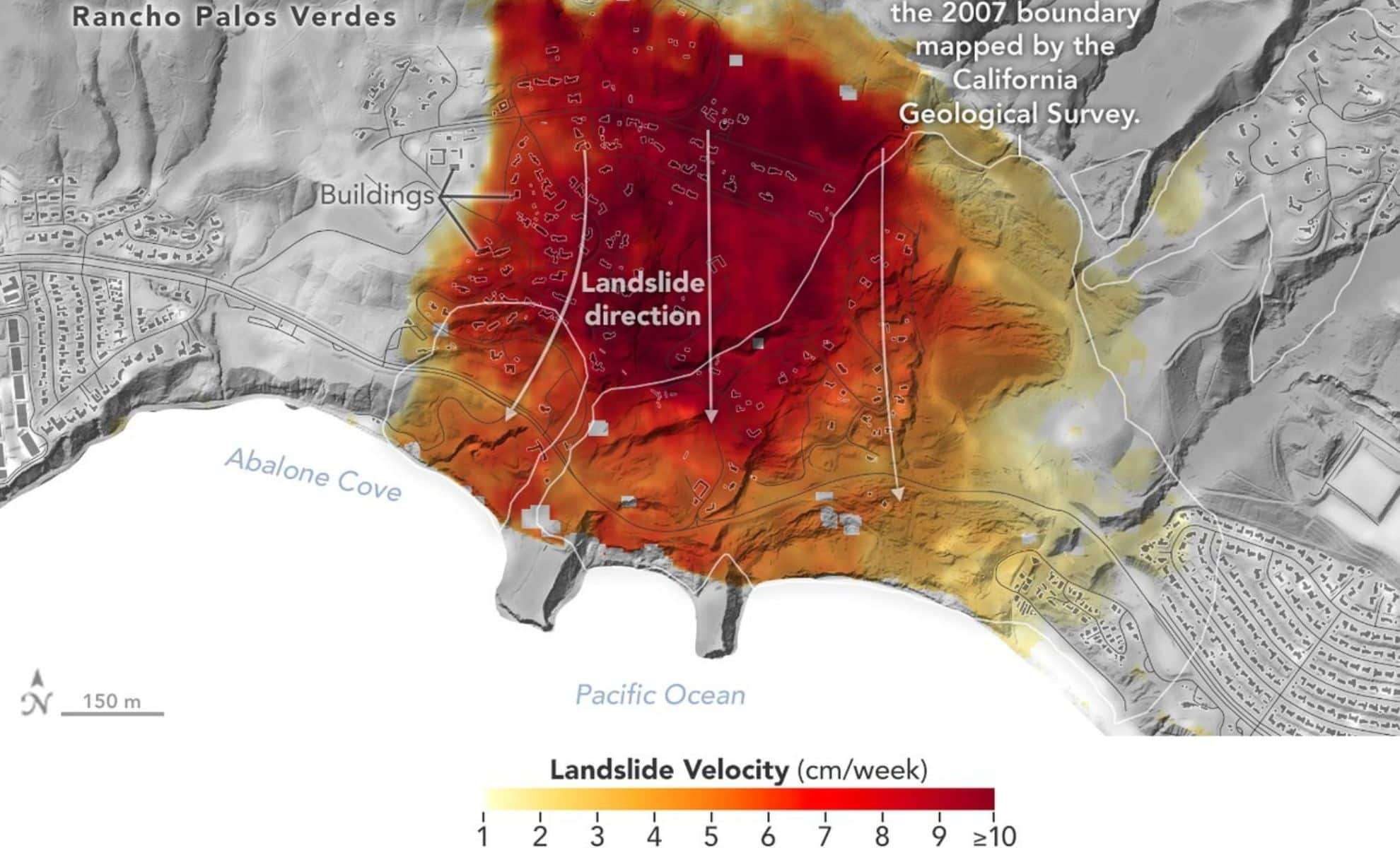
Researchers at NASA’s Jet Propulsion Laboratory (JPL) have detected alarming new data regarding landslide activity in the Los Angeles region, utilizing state-of-the-art airborne radar technology to monitor land shifts over time. Their recent analysis shows that certain zones are moving as fast as 4 inches per week, dramatically increasing the scale of affected terrain. The investigation zeroed in on the Palos Verdes Peninsula, a location already marked by unstable geological conditions, where ongoing heavy rainfall in 2023 and early 2024 appears to have intensified ground mobility.
The escalating ground deformation poses significant threats to nearby communities, infrastructure, and disaster readiness efforts. With extreme weather patterns becoming more common and intense, landslide-prone regions face greater vulnerability. By employing precise radar measurements from airborne and satellite instruments, NASA scientists can now chart these surface changes with exceptional detail. These insights not only aid researchers but also equip California emergency officials with critical data to enhance risk mitigation and protect homes and public systems.
NASA’s Methods for Monitoring Landslide Expansion
In a mission carried out between September and October 2024, NASA utilized the Uninhabited Aerial Vehicle Synthetic Aperture Radar (UAVSAR) to survey the Palos Verdes Peninsula. This advanced radar tech captures high-resolution images of land displacement, revealing patterns invisible to the naked eye. Unlike traditional satellite snapshots, UAVSAR detects small elevation changes over short intervals, allowing scientists to measure the speed and vector of land movement accurately.

Analysis confirmed that parts of the Palos Verdes area are shifting as quickly as 4 inches weekly, qualifying it as one of California’s most rapidly evolving landslide regions. This movement exceeds earlier estimates, indicating not just instability but an expansion of the affected zones beyond previously known borders. The findings suggest that unusually heavy precipitation in recent years has likely exacerbated the ongoing ground shifts, accelerating a process active for many decades.
These dynamics are illustrated in color-coded mappings where darker red shades highlight the fastest moving areas. NASA has made these visualizations accessible to the public and shared them with local emergency management agencies via the Disaster Mapping Portal. Such tools are crucial for pinpointing vulnerable locations and guiding protective measures before further damage occurs.
Summary of NASA’s Landslide Observations
Increasing Landslide Risks Across California
In California, landslides that threaten steep coastal and historically unstable zones are a constant hazard. The Palos Verdes Peninsula has experienced gradual geological shifts for many years, but recently the frequency and magnitude of these changes are intensifying. Record rainfalls in 2023 and early 2024 have saturated the soil, increasing slope weight and instability to trigger faster landslide activity.
These conditions endanger local neighborhoods, transportation routes, and critical infrastructure situated within vulnerable ground areas. As the land continues to move, the chance of foundation cracks, road failures, and damage to underground services grows, posing serious economic and safety threats. Real-time monitoring of this activity gives planners, geologists, and first responders a vital resource to manage fallout and limit disaster.
Scientists attribute the acceleration to a combination of coastal erosion, seismic forces, and increasingly extreme weather—trends projected to persist. If unchecked, land shifts on the Palos Verdes Peninsula could become more severe, risking additional homes and roadways. Ongoing detection and surveillance are critical to early hazard identification and prevention.
Future Uses of NASA’s Radar Data in Landslide Prediction
A key advantage of NASA’s radar research lies in its capacity for continuous monitoring on a broad scale. Unlike manual field surveys, UAVSAR allows unobstructed, large-area observations from the air with remarkable precision. This makes it an invaluable asset for anticipating new landslide events and designing damage-reducing interventions.
The current Palos Verdes investigation is part of a bigger initiative to advance landslide detection statewide. NASA aims to extend the use of satellite and airborne radar platforms across other at-risk locations, deepening understanding of how climate dynamics influence geological hazards. Upcoming projects will pursue:
- Expanding UAVSAR data collection to additional known landslide hotspots
- Improving early warning mechanisms for people living near unstable terrain
- Creating enhanced models to forecast future ground movements
- Partnering with governmental agencies to implement policy and safety upgrades
The forthcoming Landslide Climate Change Experiment, spearheaded by NASA, will leverage radar technology to investigate how extreme weather events impact landslide behavior over time. This research aims to better prepare for and respond to landslide disasters in the future.
Preparing for Upcoming Landslide Challenges
Given the ongoing expansion of landslide-affected zones, both officials and scientists in California are urged to collaborate on strengthening risk reduction frameworks. Key future steps include:
- Reinforcing infrastructure in zones prone to movement to minimize damage
- Launching outreach campaigns that raise awareness of landslide dangers among residents
- Updating construction regulations to reflect geological risks during development planning
- Investing further in remote sensing technologies for continuous terrain monitoring
NASA’s advancements in radar-enabled disaster tracking establish a new paradigm for understanding and mitigating natural threats. By pushing these innovative tools forward, scientists are proactively safeguarding communities, vital infrastructure, and lives from the increasing threat of expanding landslides.
Concluding Remarks: A Crucial Alert for Tomorrow
The landslide activity surrounding Los Angeles clearly demonstrates how intensifying weather extremes can exacerbate geological hazards. With NASA’s radar systems, we gain an unprecedented window into the processes driving these land shifts—and insight into their potential future trajectory.
As changing climate fuels more variable rainfall, enhancing monitoring capabilities, infrastructure planning, and emergency readiness is critical. Detailed knowledge of the speed, direction, and drivers of land movement will be vital for averting further disasters.
Going forward, experts will continue honing radar-based detection methods to forecast and mitigate landslide threats. This study serves as a stark call to action, reminding us that the ground beneath us is not fixed and that preparedness against natural hazards must be a top priority.
- Categories:
- News


0 comments
Sign in to Comment