

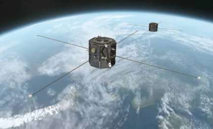
NASA and the French space agency CNES have collaboratively launched the Surface Water and Ocean Topography (SWOT) satellite, a cutting-edge instrument designed to advance oceanic observation. This satellite has demonstrated exceptional capability in tsunami analysis, especially after the 8.8-magnitude quake near Russia's Kamchatka Peninsula on July 30, 2025. As reported in a NASA article, SWOT’s data captured just over an hour after the earthquake significantly enhanced tsunami forecasting accuracy. This endeavor harnesses state-of-the-art satellite technology to deepen our understanding of tsunami dynamics, ultimately aiding in life preservation and damage mitigation for at-risk coastal zones. The collaboration compares SWOT’s live data with NOAA’s predictive models, marking a vital improvement in early warning systems for tsunami-threatened communities.
SWOT Satellite’s Role in Capturing Tsunami Data and Refining Forecast Methods
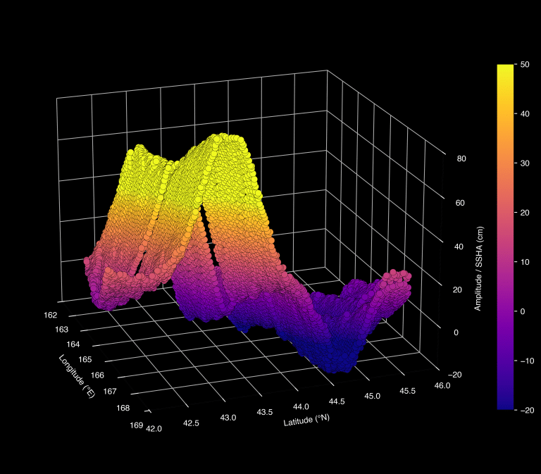
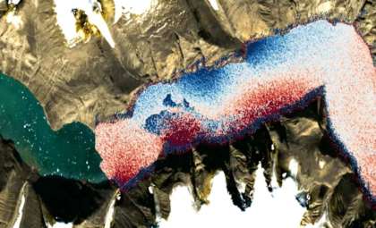
Following the seismic event in Kamchatka, the SWOT satellite recorded critical information on the ensuing tsunami. Roughly 70 minutes post-quake, it measured the wave’s elevation, shape, and trajectory, enabling researchers to validate forecast models with unsurpassed detail. This mission signifies a major technological breakthrough with its wide-reaching, high-resolution ocean coverage and near-real-time data, which are invaluable to refinement efforts by organizations such as NOAA. These advanced models forecast tsunami paths and potential impacts, offering essential data to vulnerable populations.
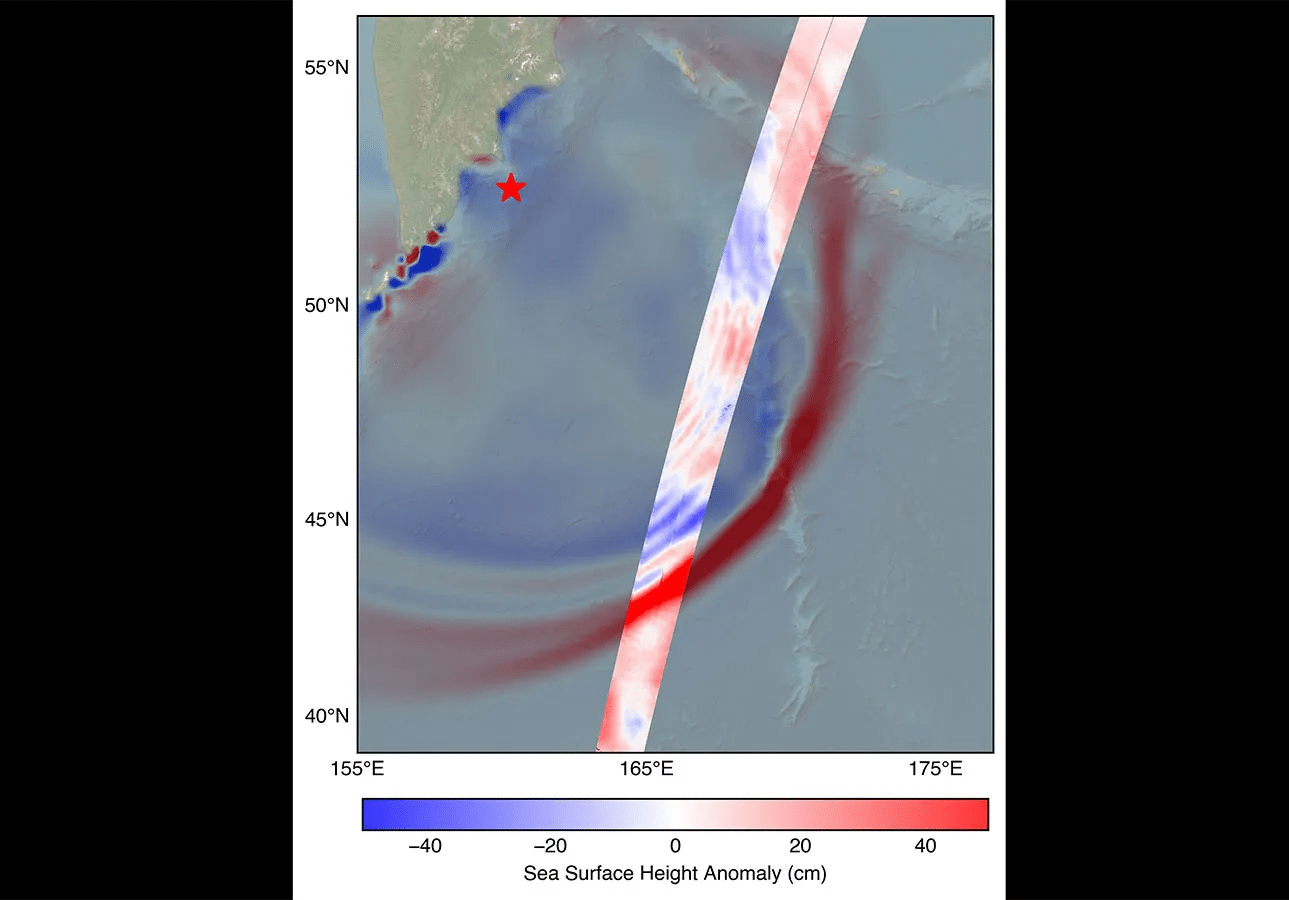
A chief advantage of SWOT lies in its extensive coverage combined with detailed resolution, permitting the measurement of the tsunami’s leading edge height—a key factor in assessing wave strength and destructive threat. Nadya Vinogradova Shiffer, NASA’s Earth lead and SWOT program scientist, states, “SWOT’s broad, sweeping ocean measurements provide indispensable real-world confirmation, uncovering new physics and advancing the precision of early warning systems for safer communities.” This underscores the satellite’s critical role in enhancing decades-old tsunami prediction techniques.

Utilizing SWOT Observations to Confirm Tsunami Forecasts
SWOT’s observations serve a crucial function in verifying forecasting outputs from NOAA and other tsunami research bodies. During the Kamchatka incident, the satellite’s data was juxtaposed with NOAA’s predictions, offering an essential real-world evaluation of forecast fidelity. Researchers at NOAA, including oceanographic experts and engineers, depend on such satellite insights to enhance and fine-tune their models. This validation bolsters confidence in issuing timely warnings that can substantially diminish threat levels to coastal inhabitants and infrastructure.
NASA JPL oceanographer Ben Hamlington explains the criticality of even modest wave measurements: “While a wave height of 1.5 feet may appear insignificant, tsunamis span from ocean floor to surface. Such a wave might amplify to 30 feet upon reaching shallow coastal waters.” This perspective highlights the vital importance of precise early wave detection and height assessment in projecting tsunami impact scale.
Enhancing Worldwide Tsunami Preparedness Through SWOT
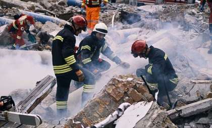
Tsunamis remain among the deadliest natural hazards, causing widespread casualties and economic devastation in coastal areas. The catastrophic 2004 Sumatra tsunami exposed significant gaps in global early warning capabilities, especially in resource-limited nations. SWOT’s sophisticated observational technology now offers a transformative tool for bolstering worldwide tsunami readiness.
By incorporating SWOT’s high-fidelity data into present predictive frameworks, researchers can generate more precise, location-specific forecasts. This empowers local disaster response agencies to deliver faster, more credible alerts. SWOT’s insights also aid in distinguishing between tsunamis likely to produce minimal versus severe effects based on wave characteristics like size and velocity, a vital aspect for risk reduction.
Moreover, SWOT advances fundamental knowledge of tsunami origination by capturing intricate wave dynamics and seafloor interactions. This information supports the development of improved predictive models detailing how tsunamis form, travel across oceans, and impact coastal regions, contributing to stronger resilience and mitigation strategies worldwide.
- Categories:
- News


0 comments
Sign in to Comment