

In September 2023, an extraordinary natural event in Greenland's Dickson Fjord shocked scientists worldwide. A colossal tsunami generated by a massive landslide produced seismic waves detected on a global scale. This remarkable occurrence persisted for days, sending powerful ripples thousands of miles away, from Alaska across to Australia. Researchers struggled to interpret these unusual seismic signals, which defied normal earthquake characteristics due to their slow and enduring nature.
A One-of-a-Kind Tsunami Event
On September 16, an immense volume of 25 million cubic yards of rock and ice plummeted from the towering cliffs of Greenland’s Dickson Fjord, generating a rare mega-tsunami with waves soaring up to 650 feet (approximately 0.2 km). The tremendous crash sent shockwaves reverberating through the fjord and far beyond. When the wave reached the shoreline, it reflected back, creating a seiche—an oscillating water motion—causing continuous sloshing that intensified seismic signals in the region.
The immediate impact was devastating, as waves engulfed a scientific station on Ella Island, damaging gear valued at $200,000. Rather than subsiding, this turbulent motion rumbled for days, producing a persistent back-and-forth movement within the fjord. The prolonged disturbance generated an atypical seismic footprint, differing markedly from conventional earthquake records.


Decoding the Unusual Seismic Signature
The seismic aftermath puzzled researchers deeply. Unlike typical earthquake signals characterized by chaotic waves, this event produced smooth, periodic oscillations occurring every 92 seconds, continuing unabated for nine days. Such prolonged, rhythmic seismic activity was unprecedented and initially defied explanation.
Over 70 scientists worldwide collaborated to identify the cause of this global seismic pulse. Their research linked the phenomenon directly to the landslide-triggered tsunami. Alice Gabriel from UC San Diego’s Scripps Institution of Oceanography remarked on the complexity, stating, “Accurately simulating such an enduring, sloshing tsunami posed a significant challenge.”
Simulation efforts estimated wave heights reaching around 30 feet, though some discrepancies in measurements remained among the experts.
Advanced Satellites Reveal The Phenomenon
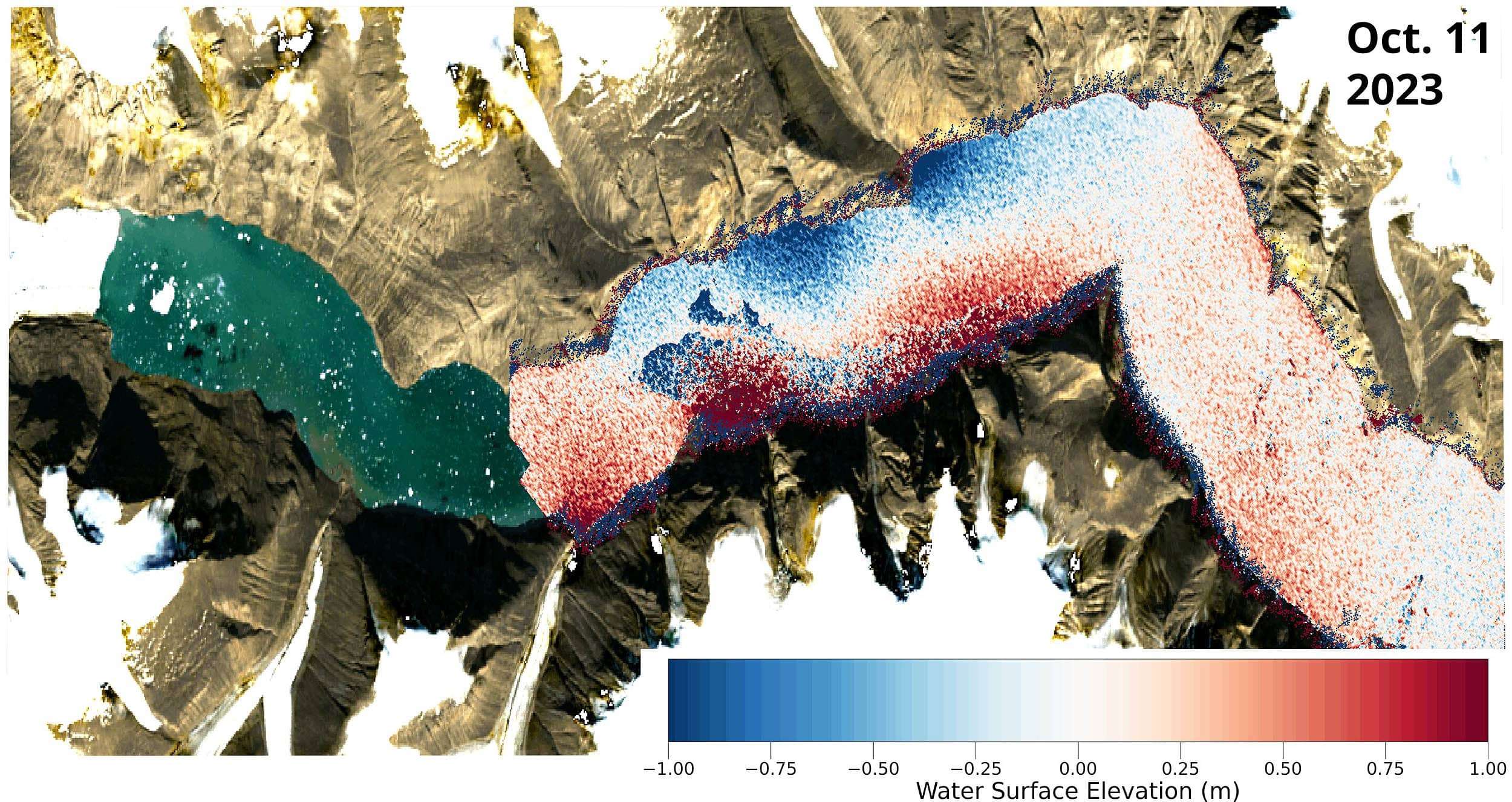
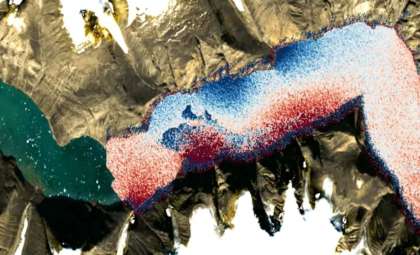
Key insights came from cutting-edge satellite observations. The Surface Water and Ocean Topography (SWOT) satellite, launched in late 2022, captured high-resolution imagery of the post-tsunami fjord. Unlike traditional satellite radar systems, SWOT scans a broad 30-mile-wide area with exceptional 8-foot detail, allowing scientists to visualize the wave's interaction with the fjord's terrain in unrivaled detail.
Thomas Monahan of Oxford University highlighted the satellite’s impact: “Next-generation Earth observation platforms like SWOT are revolutionizing how we study these dynamic environments.” The satellite’s capabilities enable unprecedented monitoring of remote Arctic regions, offering a clearer picture of Greenland’s dramatic natural forces.
Rising Climate Concerns in the Arctic
The origin of this tsunami within Greenland’s icy, isolated environment shines a spotlight on the Arctic’s increasing fragility. As global warming intensifies, accelerated melting of glaciers and ice sheets destabilizes slopes and cliffs, raising the likelihood of similar events in the future.
Kristian Svennevig from the Geological Survey of Denmark and Greenland emphasized that climate change is already triggering new geological phenomena, such as the landslide behind this tsunami. The rapidly transforming Arctic landscape faces mounting environmental pressures due to these shifts.
This incident illustrates how climate change is not a distant concern but an active factor reshaping Earth’s environments. Greenland’s thaw may be increasing landslide occurrences, thereby elevating tsunami risks and complicating hazard preparedness.
Increased human activity in the Arctic, from tourism to scientific exploration, makes the need for enhanced early-warning systems pressing. Combining real-time seismic monitoring with satellite data will be key to managing future threats.
The detailed findings are available in the journals Science and Nature Communications.
- Categories:
- News


0 comments
Sign in to Comment