

A newly identified circular fault structure lies beneath Campi Flegrei, one of the globe’s most monitored volcanoes, thanks to an extensive seismic investigation utilizing artificial intelligence. This previously undetected fault reveals critical zones of subterranean stress and could clarify the recent increase in local seismic events.
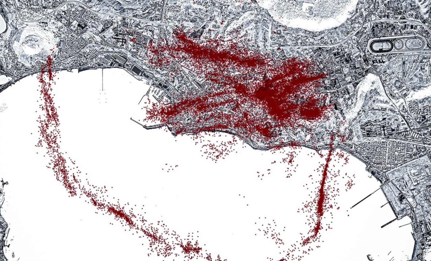
By processing data from over 54,000 earthquakes recorded since 2022, scientists have delineated a distinctive ring-shaped fracture that closely matches observed areas of surface uplift — a clear indication of dynamic processes underground. This landmark study, spearheaded by Xing Tan, a PhD candidate at Stanford University, offers unprecedented insight into the volcano’s underlying activity.
Campi Flegrei, located just west of Naples, is situated right beneath bustling communities, roads, and residences. Unlike secluded volcanic sites, this caldera’s proximity to populated areas makes the discovery especially consequential. While scientists have long observed its seismic tremors and swelling episodes, the newly revealed fault network sheds light on the structural reasons behind these phenomena.

AI Detects Hidden Circular Fault Amid Seismic Noise
Traditional monitoring near Campi Flegrei involved manually identifying initial seismic waves from events. Tan’s team revolutionized this approach by deploying machine learning algorithms trained on thousands of waveforms, enabling detection of subtle overlapping quakes missed before. This breakthrough led to an extensive catalog of 54,000 seismic events.
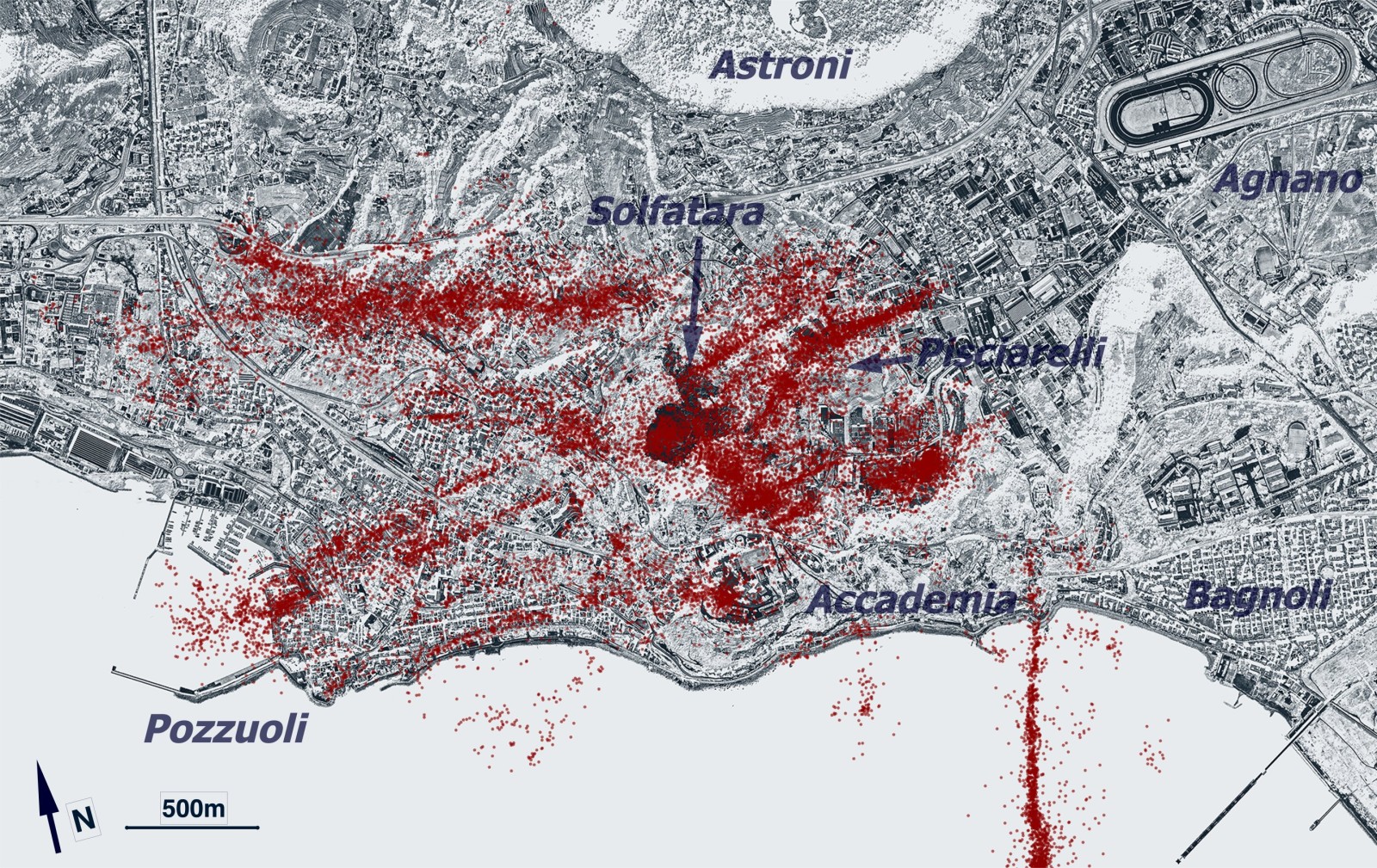
The findings, detailed in a study published in Science, highlighted a sharply defined ring fault typical of collapsed caldera boundaries. This circular fracture not only encompasses the central uplift but also extends offshore, revealing a more extensive structure than earlier recognized.
“Our Italian colleagues were surprised to see the ring so clearly,” the lead author noted. Ring faults matter because they help guide stress—where it builds and where it might be released.
Intersecting Faults Discovered Beneath Pozzuoli City
Disturbingly, the research also uncovered two major faults crossing beneath Pozzuoli, a city situated at the caldera’s northern rim. Unlike isolated volcanic regions, this urban area is vulnerable to even small tremors that could impact structures and residents. The intersection of these faults at a shallow depth—under 4 kilometers below ground—raises additional concerns.
Currently, no clear signs of magma intrusion toward the surface have been detected. Instead, the earthquakes seem driven by pressurized fluids migrating through fractured rocks. While there is no indication of an eruptive onset, moderate earthquakes remain a possibility, with researchers warning that a magnitude 5 event could occur, especially given the faults’ location beneath populated zones.
Fault Mapping Enhances Volcano Risk Management Strategies
One of the most significant aspects of this research is that the new fault monitoring system is already operational. The AI-based detection runs in real-time, tracking fresh seismic events and stress variations throughout the caldera, providing critical data for hazard mitigation.
Earth.com reported that since April 2025, the ground level has been rising steadily by around 15 millimeters monthly. While subtle, such sustained uplift can increase stress on local structures and modify underground fault dynamics. With confirmed ring fault locations, emergency planners now have clearer targets for evaluating shaking risks.
Italy’s Civil Protection Agency currently designates areas into red and yellow hazard zones. Integrating the latest fault maps can help refine these divisions, optimizing shelter locations, evacuation pathways, and inspection priorities for buildings in vulnerable areas.
- Categories:
- Science


0 comments
Sign in to Comment