
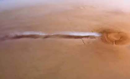
An enormous, unusual formation spotted on satellite images across the Nullarbor Plain in Australia led researchers to uncover the evidence of a powerful tornado that went entirely unnoticed by locals. The only sign of the event was a lengthy scar etched into the terrain.
The discovery began when a cave explorer noticed a strange line slicing through the barren landscape on Google Earth. This initial observation drew the attention of scientists, who decided to investigate the phenomenon further.
In the isolated environment of the Nullarbor Plain, with its sparse population, significant weather events often occur without being observed firsthand. Therefore, satellite monitoring combined with on-site analysis remains crucial to reconstructing such episodes.

Enigmatic 11-Kilometer Path Confounds Experts
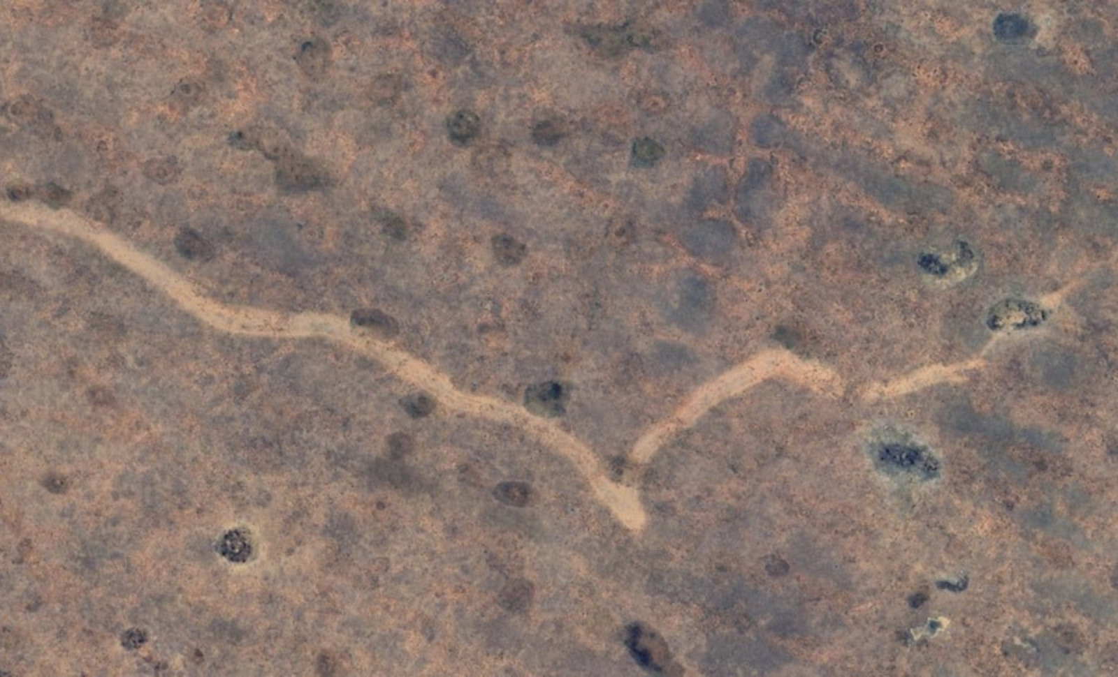
The mark extends over a distance of about 11 kilometers, with a width ranging from 160 to 250 meters, crossing from Western Australia into South Australia. Details published in the Journal of Southern Hemisphere Earth Systems Science reveal how researchers compared successive satellite photos to identify the feature.
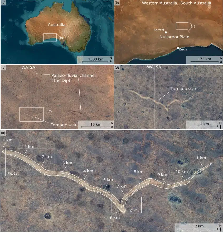
The timing was pinpointed to a narrow window between November 16 and 18, 2022. During this period, the images also showed circular blue areas likely representing temporary water pools formed by intense rainfall.
The team associates these indicators with a severe storm system traversing the region. The scar’s position is about 20 kilometers north of the Trans-Australian Railway and nearly 90 kilometers east-northeast of Forrest, a now-abandoned railway settlement.
Compelling Evidence Suggests a Severe Tornado
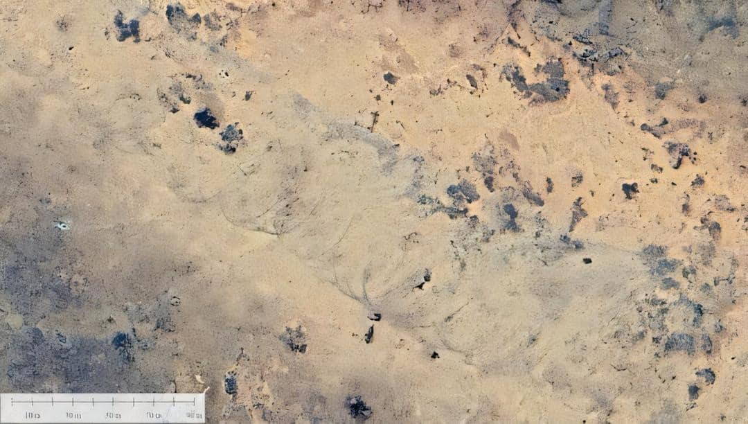
Field examinations conducted months after the event uncovered distinctive cycloidal patterns along the scar. Meteorologist Dr. John Allen, unaffiliated with the study, commented:
“Cycloidal marks are quite evident, and these are seen in US tornado damage paths.” he added, “The appearance of the path without substantive evidence of flooding as an alternative cause would further lend support to this argument.”
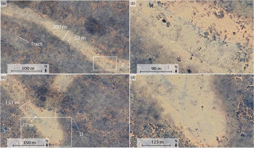
According to the research, the storm reached an estimated F2 to F3 on the Fujita scale, with wind speeds surpassing 200 km/h. The tornado appeared to have moved in a west-to-east trajectory while rotating clockwise. It likely persisted for 7 to 13 minutes, leaving an unmistakable trail on the environment.
Contemporary meteorological data recorded during the event indicate heavy cloud cover and significant rainfall, supporting the conclusion that the scar resulted from a violent storm. The erosion observed along the path illustrates extensive ground disturbance, with soil and vegetation torn away by fierce winds.
Tornado’s Passage Went Unseen Due to Remote Location
Despite the tornado’s intensity, it did not impact any inhabited areas or infrastructure. The Nullarbor Plain is an extremely secluded region, characterized by vast open plains, a scarcity of trees, and minimal human presence.
The researchers emphasize that this isolation explains why no witnesses reported the event. To date, only three tornadoes have been officially documented in this area, all of which occurred during November, mirroring the timing of this recent occurrence.
This pattern suggests a possible seasonal influence, although the region remains largely understudied. Remarkably, the scar remained visible 18 months after the storm. Due to the arid conditions, vegetation regenerates slowly, leaving the landscape scarred for an extended period.
“We usually see tornadoes as eyewitnesses or concerning how much destruction they left behind,” said study author Matej Lipar, a physical geographer from the Slovenian Academy of Sciences and Arts. “But here it basically just kind of ‘signed’ itself on the surface of the Nullarbor and because there’s not much vegetation, it just remained clearly visible up until today.” That gave scientists a rare chance to study the aftermath long after the storm had passed.
- Categories:
- News


0 comments
Sign in to Comment