

A tropical wave approaching the Greater Antilles is showing signs it could evolve into Tropical Storm Debby.
The National Hurricane Center (NHC) along with forecasting models are monitoring this system as it advances toward the Gulf of Mexico and nearby Florida waters. Its movement may influence weather conditions across the southeastern United States.
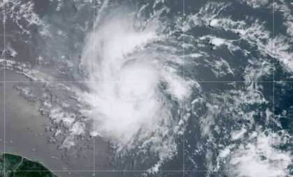
Current Conditions and Predictions
The tropical disturbance, situated around 1800 miles from New Orleans, has recently intensified its storm activity, signaling that it might soon organize into a more defined tropical system.

Dry air and Saharan dust initially hindered its growth. Yet, recent thunderstorm buildup indicates the disturbance is starting to overcome these barriers. This is a significant development as it traverses warm sea surface temperatures, which are vital for further strengthening.
Short-Term Outlook (Next 24-48 Hours)
Over the coming 1-2 days, the system is expected to proceed westward and may consolidate into a tropical depression.
Both the Global Forecast System (GFS) and European Center for Medium Range Weather Forecasting (ECMWF) models favor development due to increasingly supportive factors like warm ocean waters and minimal wind shear.
The National Hurricane Center currently estimates a 60% probability of tropical cyclone formation within this timeframe, emphasizing the need for close observation.
Key Elements Affecting Development
Several decisive environmental factors are influencing the system's evolution and path:
Sea Surface Temperatures: The Caribbean and Gulf waters remain above 80°F (27°C), creating optimal energy conditions for cyclogenesis.
Wind Shear: Reduced wind shear levels in the region help maintain system integrity, promoting organization.
Dry Air and Saharan Dust: While these initially limited the system's progress, the strengthening thunderstorm activity suggests their influence is waning, allowing moisture levels to rise.
Mid-Term Projection (3-5 Days)
Heading into the weekend, the system is anticipated to near the eastern Gulf of Mexico or waters off Florida. Both ECMWF and GFS are projecting a westward course, guided by the Bermuda High.
This high-pressure area could steer the disturbance toward the Gulf, where conditions may support further intensification into a named tropical storm. The forecast includes possible interactions with Hispaniola and Cuba, which may temporarily disrupt its structure.
Even if the system does not fully mature into a tropical storm, it may still bring heavy rainfall and strong winds, raising the risk of localized flooding, especially in vulnerable low-lying zones.
Extended Outlook (5-7 Days)
Beyond five days, forecasts become less certain. The future track will hinge on how the Bermuda High evolves and its interactions with the southeastern United States coast.
ECMWF and GFS models currently differ between pushing the system into the eastern Gulf, possibly impacting the Florida Panhandle, or keeping it closer to Florida’s Atlantic shore. This unpredictability underscores the importance of remaining vigilant.
Impact Assessment and Safety Recommendations
Forecasts suggest an increased chance of heavier rainfall across Florida starting this weekend, lasting into early next week, independent of whether a tropical storm forms. The NHC’s forecast of a significant development probability highlights the importance of staying updated.
The peak months of the Atlantic hurricane season—August through October—typically bring warm seas, low wind shear, and abundant atmospheric moisture that fuel tropical storm formation and intensification.
Residents along the Gulf Coast, especially in Florida, Alabama, Mississippi, and Louisiana, are urged to follow guidance from the National Hurricane Center and local forecasts.
Precautionary actions such as securing homes, preparing for evacuations, and monitoring local emergency announcements are strongly recommended as the situation evolves.
- Categories:
- News ,
- Climate change


0 comments
Sign in to Comment