
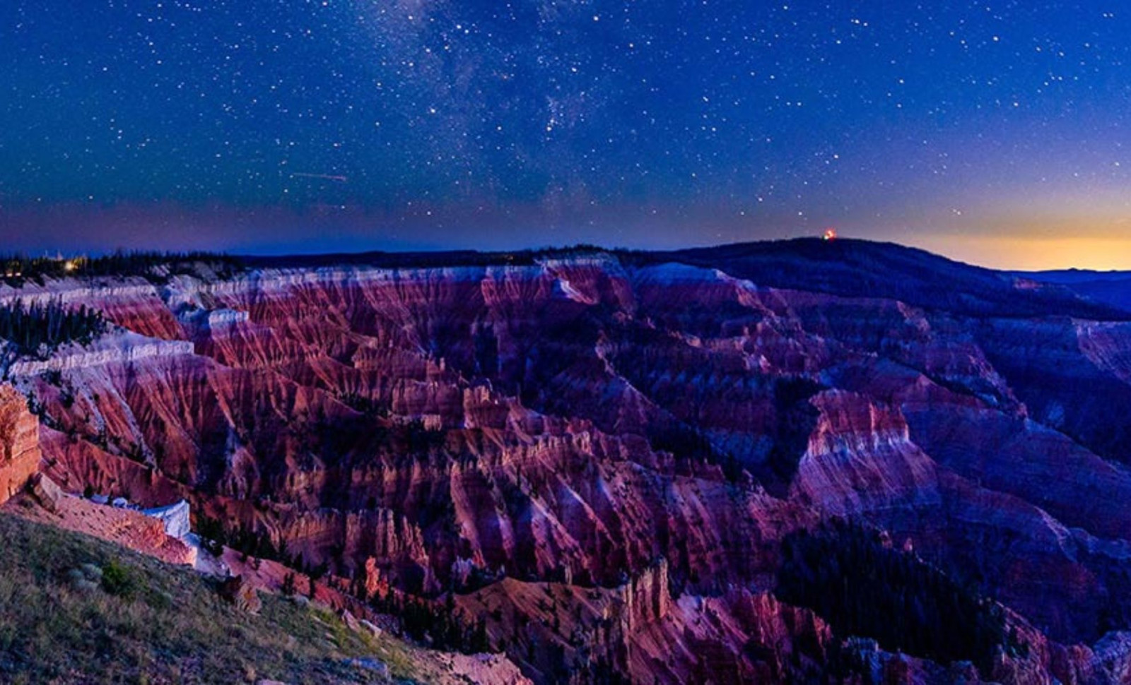
Soaring over the Utah plateau at an elevation of 10,000 feet, the striking cliffs and canyon formations within Cedar Breaks National Monument tell a tale frozen in stone. Captured by NASA’s Landsat 9, the amphitheater’s vivid hues and weathered textures showcase millions of years of Earth’s geological history.
From a bird’s-eye perspective, the semi-circular cliff face resembles a deep incision in the planet’s surface, sculpted by relentless erosion, tectonic forces, and ancient climatic variations. This satellite view chronicles an epic history of vanished lakes, volcanic activity, and primeval ecosystems embedded in layers of orange, white, and gray sediments.
The Story of Lake Claron’s Formation and Disappearance
The brilliant rock layers at Cedar Breaks originated from an ancient lake known as Lake Claron, which occupied a substantial basin during the Eocene to Oligocene periods, approximately 50 to 25 million years ago. Over many millennia, fine carbonate-rich sediments accumulated on the lake floor, eventually hardening into the limestone formations visible today.

Variations in water levels and shifts in environmental conditions influenced the chemical properties of these sediments. As detailed by the NASA Earth Observatory, wetter periods limited oxygen exposure, resulting in pale, iron-deficient rocks, while drier phases promoted the formation of iron-rich, reddish-orange layers. These color contrasts provide a visual record of ancient climate cycles preserved in stone.
Captured through ground-level photography and Landsat images, this geological palette allows scientists to decode the canyon’s environmental narrative without physically disturbing the site.
A Geological Stairway Among the Peaks
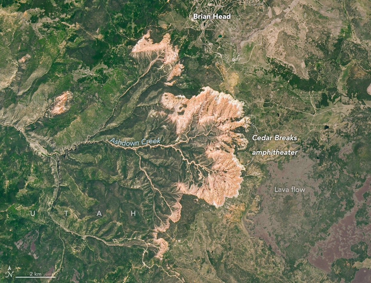
The monument lies atop the Grand Staircase, a vast sequence of sedimentary strata stretching from southern Utah to the Grand Canyon. Following deposition, tectonic forces gently uplifted these layers to heights surpassing 10,000 feet, making Cedar Breaks a key point of geological interest.
Deep channels carved by watercourses such as Ashdown Creek and its tributaries etch the amphitheater’s rim, illustrating the powerful erosional processes at work.
“The high elevation influences everything from the weather to the plants and animals that live there. Winters are long, cold, and snowy, with nearby Brian Head seeing 30 feet (10 meters) of snowfall each year on average,” said the report.
Despite harsh winters, tough bristlecone pines thrive along the exposed limestone edges. Some of these resilient trees exceed 1,700 years in age, surviving by growing slowly and using their dense wood to resist decay, symbolizing endurance in a challenging environment.
Traces of Volcanic Activity
In addition to sediment and water, volcanic events shaped parts of Cedar Breaks more recently. From about 5 million to 10,000 years ago, eruptions on the Markagunt Plateau deposited dark basaltic lava flows and tuff layers along the canyon edges.
According to NASA, these volcanic remnants can be seen east of the monument, where pyroclastic flow deposits from past explosive eruptions cover the landscape around Brian Head, now a popular ski destination.
- Categories:
- Science


0 comments
Sign in to Comment