
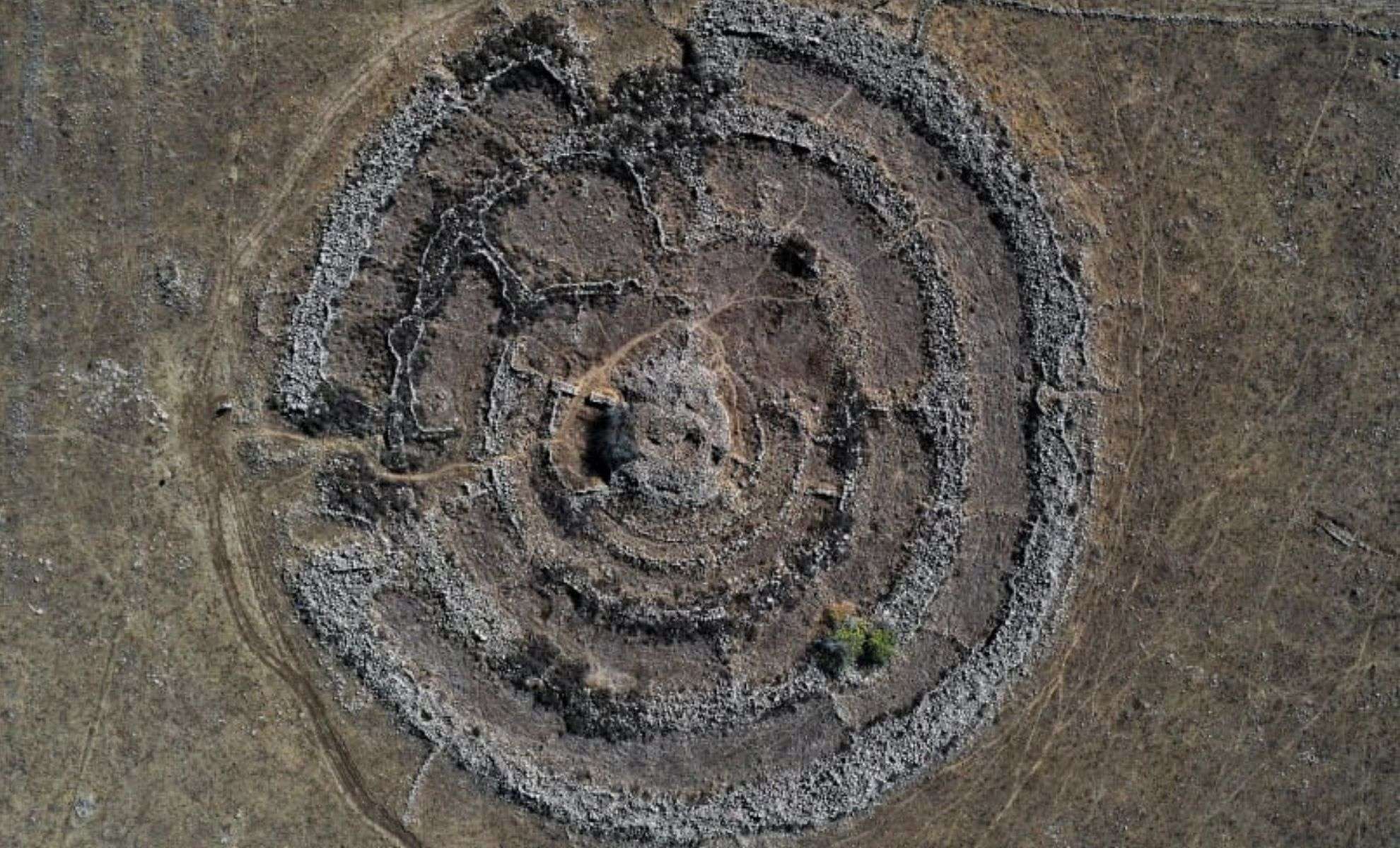
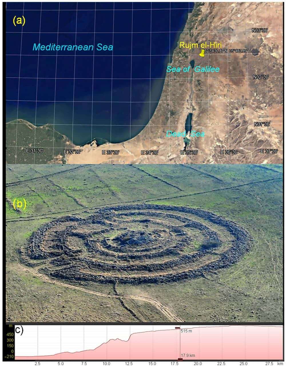
For many years, the prehistoric site known as Rujm el-Hiri—sometimes called the Israeli Stonehenge—has intrigued scholars and enthusiasts alike. Situated in the Golan Heights, this Bronze Age monument features expansive concentric stone circles stretching approximately 160 meters across and rising to heights of 2.4 meters. Referred to as “Gilgal Refaim,” or the “Wheel of Giants” in Hebrew, the site was for a long time presumed to be a sophisticated astronomical observatory due to its elaborate design and apparent celestial alignments. However, recent investigations led by researchers from Tel Aviv University and Ben-Gurion University have overturned this explanation, providing a new understanding of its origins and intended use.
The latest research, published in the journal Remote Sensing, integrates geomagnetic surveys, tectonic assessments, and cutting-edge imaging methods. The scientists determined that geological changes over millennia have shifted the terrain significantly, disturbing the original layout and making it unsuitable for precise celestial tracking. This revelation questions earlier assumptions and invites fresh speculation regarding the structure’s real function.
Impact of Geological Movements on Astronomical Alignment
At the core of this study is the geological evolution of the Golan Heights. This region rests on an active tectonic zone that has been moving for more than 150 million years, with rates varying between 8 and 15 millimeters per year. These continual shifts have altered the positioning of Rujm el-Hiri’s circular walls and gates, disrupting their alignment with key astronomical phenomena such as solstices and equinoxes—from when the monument was built, roughly between 2500 and 3500 BCE, to today.

Employing satellite data, geomagnetic mapping, and soil examinations, researchers reconstructed how the site originally aligned with the sky. Their analysis indicates that the current arrangement does not correspond with any known Bronze Age celestial patterns. This strong misalignment implies that the site was unlikely conceived as an observatory for tracking stars or solar events.
A Mystical Stone Landscape Rich in History
Rujm el-Hiri exists within a wider archaeological context in the Golan Heights beyond its central stone structure. Surrounding it are several smaller circular formations, burial mounds (tumuli), and extensive stone walls. These additional features imply that the complex might have served multiple roles, possibly including communal gatherings, agricultural functions, or spiritual ceremonies.
The tumuli scattered around are particularly noteworthy. Traditionally used as burial sites, these stone mounds suggest that the location may have held sacred significance or been part of ritual practices. Moreover, the presence of robust stone enclosures, measuring anywhere between 40 to 90 meters in diameter, supports the idea of the site serving pastoral or agricultural purposes as well.
Placed within a broader network of ancient Mediterranean monuments from the Chalcolithic and Early Bronze Age, Rujm el-Hiri shares architectural motifs such as concentric circles and radial walls. This indicates cultural links and architectural traditions exchanged among communities of that era.
Cutting-Edge Technology Revolutionizing Archaeology
The research on Rujm el-Hiri highlights how contemporary technologies are transforming the field of archaeology. Through remote sensing, satellite imagery, and geomagnetic investigation, scientists have accessed information that was previously hidden. These high-tech methods have exposed the extent of tectonic changes and helped map the site's structure in fine detail, along with its connection to the surrounding environment.
Remote sensing techniques, particularly, have been instrumental. Analyzing satellite images within a 30-kilometer radius of the monument, experts identified numerous previously uncharted archaeological sites including additional circular enclosures, ancient pathways, and remnants of historic farming systems. This approach enables archaeologists to understand these locations in a wider environmental and historical framework—something difficult through traditional excavation alone.
Reevaluating the True Role of Rujm el-Hiri
With evidence now contradicting the idea that Rujm el-Hiri was an astronomical tool, researchers are considering alternative interpretations of the site’s function. One theory suggests it may have acted as a ceremonial center, where local Bronze Age societies conducted rituals and social events. Its prominent placement and grand scale imply it was a location of notable cultural or spiritual importance.
Another perspective emphasizes practical uses related to farming or animal husbandry. The stone enclosures and walls could have been designated spaces for keeping livestock or storing harvests. The tumuli might have doubled as grave sites and boundary markers for territory or resource control.
Moreover, the symbolic meaning of the complex cannot be overlooked. The elaborate layout and monumental construction reflect a society with sophisticated organizational skills and a profound connection to the land. Whether as a ritual space, a functional agricultural hub, or a combination of both, Rujm el-Hiri stands as a remarkable testament to its creators' ingenuity and societal complexity.
- Categories:
- News


0 comments
Sign in to Comment