
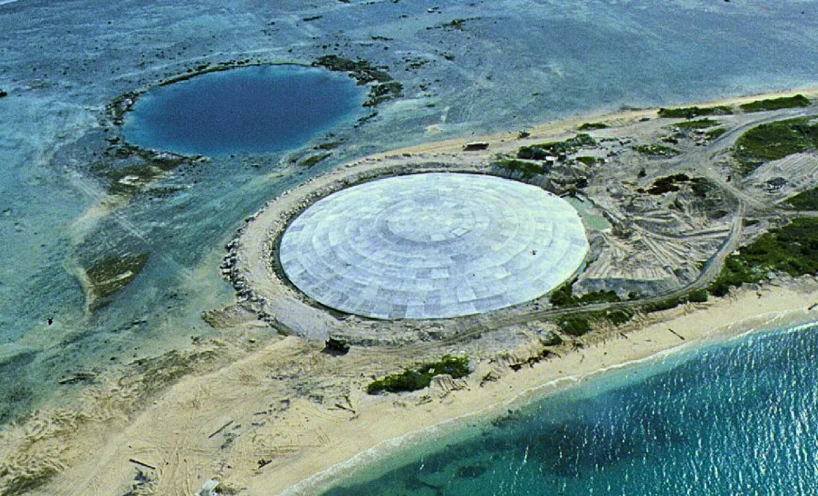
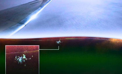
On Runit Island in the Marshall Islands, a concrete barrier rests precariously near the Pacific Ocean's edge, so close that the water seems integrated with the structure itself. Footage from October 2017 revealed how narrow the strip of land is between the dome and open sea. It is a place where the gentle movements of the lagoon behind you can be clearly heard.
Almost fifty years earlier, Robert Celestial arrived at Enewetak Atoll serving as a United States Army truck driver on an assignment in 1978 that was never fully explained to him. He recalled pumping water out of a crater, believing he was only managing remnants from World War II. He was unaware that the crater had been formed by a nuclear explosion.
“We were confined on a tiny Pacific island with 500 men, like being stuck on Alcatraz. There was no escape,” he recalled. His instructions were straightforward: relocate "contaminated" soil to a nearby island and deposit it into a crater. That destination was Runit Island.

This story traces back to intense Cold War nuclear testing. Between 1946 and 1958, the U.S. detonated 67 nuclear devices at Enewetak and Bikini Atoll, displacing more than 300 Marshallese residents to facilitate the program. One notable explosion, the 18-kiloton Cactus test, obliterated part of Runit and sent a mushroom cloud soaring about 6 kilometers high.
Two decades post-Cactus, the resulting crater—roughly 10 meters deep—was repurposed to contain over 120,000 tons of contaminated soil and debris gathered around the atoll. Celestial described making countless trips, unloading radioactive waste from his truck. Once the operation ended, the crater was capped with an 18-inch concrete dome, now known locally as the Runit Dome.
The Crater Converted into a Waste Repository
The cleanup never left Celestial unscathed. After returning to the mainland, he developed painful boils that broke through his skin. He was medically discharged after seven years and later faced conditions including brittle bones, osteoporosis, arthritis, and kidney and liver ailments, requiring ongoing treatments.
It remains uncertain whether all his health problems stem from the nuclear cleanup efforts. The Atomic Heritage Foundation has documented that many veterans experienced cancers and weakened bones following their six-month tours on Enewetak. It was not until 2023 that the US government granted official recognition to these "atomic veterans," enabling them to apply for disability benefits.
Celestial highlighted both the workforce's size and the dire survival rate. Of approximately 4,000 service members assigned to Enewetak during the 1970s and ’80s cleanup, only a few hundred remain alive today, according to the National Association of Atomic Veterans. He stressed the hazardous working conditions, with radioactive materials often handled casually amid operational disorganization.
“We did not perform the cleanup properly,” he said, noting that crews were often unaware of protocols, and that equipment alongside contaminated materials was sometimes dumped directly into the lagoon. Since the lagoon remains a vital resource for nearby island populations, concern persists about the waste stored beneath the dome.
Visible Signs of Structural Compromise
More than half a century later, the dome exhibits clear signs of decay: cracks have appeared throughout the concrete shell, and groundwater flows beneath the structure. As reported by ABCNews, tides cause groundwater to move under the dome, raising concerns that contaminants could leach into the surrounding lagoon. Numerous scientific studies have confirmed the presence of fissures in the concrete, while a United Nations report highlighted that the dome is not fully sealed against water intrusion.
Ivana Nikolic-Hughes from Columbia University, who also presides over the Nuclear Age Peace Foundation, observed these cracks firsthand during radiation measurements in 2018. She detected elevated radiation levels in soil samples outside the dome. With rising sea levels and intensified storms, she warned that the dome’s structural integrity might be severely threatened.
Geographically, she noted that Runit Island lies about 20 miles (32.19 km) from inhabited communities who rely on the lagoon for sustenance. According to the 2021 census, some 300 people reside on Enewetak, and approximately 600 live on Enetewak Atoll. In contrast, Bikini Atoll remains too polluted for resettlement, including Bikini Island itself, the highest atoll in the Marshall Islands.
Debate Surrounding Potential Contaminant Leakage
US officials maintain that the dome is not on the brink of collapse. The United States Department of Energy attributed the cracks to normal aging of the concrete and argued that the lagoon already contains significant radioactive contamination from testing, meaning any additional leakage from the dome is comparatively minor.
Nikolic-Hughes disputes this viewpoint, questioning why the dome was constructed if the lagoon's radioactivity dwarfed its contents. She suspects the structure encloses not only contaminated soil but possibly unexploded ordnance from nuclear tests, although this remains unconfirmed. Her worry centers on the presence of concentrated radioactive fragments versus diffuse contamination in the environment.
The timeline of nuclear decay challenges the dome’s engineering limits. Plutonium-239, a key radioactive component in nuclear weapons, remains hazardous for over 24,000 years. Arjun Makhijani, nuclear engineer and president of the Institute for Energy and Environmental Research, emphasized that no concrete structure can sustain even a fraction of that longevity, underscoring the fact that cracks have emerged in under 50 years.
An Unresolved Responsibility Amidst Rising Seas
Reports detail how the Marshallese government lacks the technical expertise and financial resources to manage the dome’s risks. Upon achieving independence via the Compact of Free Association in 1986, the Marshall Islands received extensive US funding but relinquished claims tied to nuclear testing, effectively assigning responsibility for the dome to local authorities.
Marshallese leaders have expressed that they were not fully briefed on the implications during the compact’s signing. A NASA/USGS satellite map included in the report locates the dome on Enewetak Atoll’s northeast tip, only about 30 kilometers from communities that depend on the lagoon as a food source. Its proximity means any contamination originating at Runit could impact those islanders directly.
Former Marshallese health secretary Jack Niedenthal described the dome as a symbol of an American error, noting that efforts to reinforce it have been limited to patchwork cement and ongoing studies. “With sea levels rising and everything just a few feet above high tide, it’s deeply concerning,” he commented. The ABC article, published March 14, 2026, highlighted that the cracks visible today serve as stark indicators that the structure was built to contain nuclear waste, not to withstand relentless ocean forces.
- Categories:
- News


0 comments
Sign in to Comment