
NASA’s Mars Reconnaissance Orbiter (MRO) has reached a remarkable milestone in its exploration of the Red Planet. Its HiRISE camera has just taken its 100,000th image, offering an extraordinary new look at Mars’ surface. These high-resolution photos from HiRISE not only deepen scientific understanding but are also vital for planning future human missions. The latest image, captured in October 2025, highlights significant Martian terrain, enriching our knowledge of the planet’s geology and atmosphere.
HiRISE: NASA’s Window into Mars’ Surface
For almost 20 years, NASA’s Mars Reconnaissance Orbiter has been circling Mars, capturing some of the most detailed images ever recorded of the planet’s surface. Central to this mission is the HiRISE camera, a powerful instrument delivering images with unprecedented clarity. Beyond their visual appeal, these photos hold critical clues about Mars’ environmental processes. The achievement of 100,000 images marks a significant collaborative effort to unravel the planet’s secrets.
HiRISE visuals showcase a vast array of Martian characteristics—from soaring cliffs and deep valleys to expansive sand dune fields and ancient craters. Each photograph aids scientists in piecing together Mars’ geological history, climate patterns, and surface changes. This information is indispensable for plotting landing zones for upcoming rovers or even human explorers. As Leslie Tamppari, MRO’s project scientist, has noted,

“HiRISE hasn’t just discovered how different the Martian surface is from Earth, it’s also shown us how that surface changes over time.”
Showcasing Mars: The Landmark 100,000th Photograph
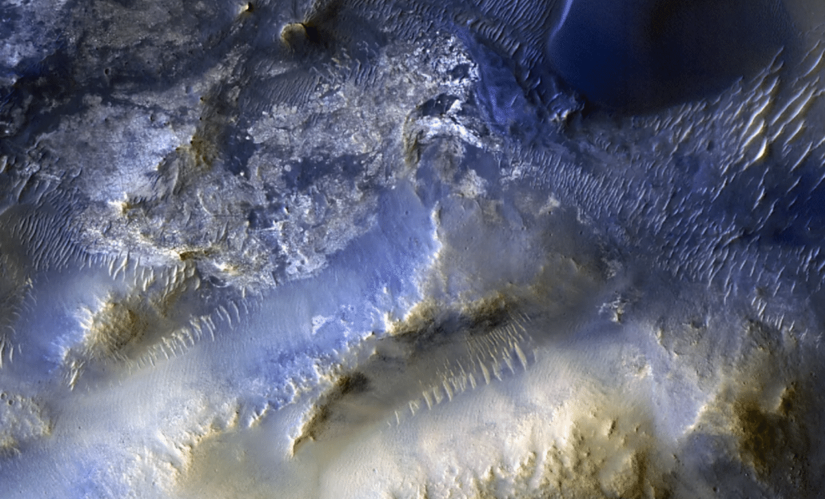
The milestone 100,000th image, captured on October 7, 2025, presents the striking landscape of Syrtis Major, a vast area located roughly 50 miles southeast of Jezero Crater. This location has attracted scientific attention due to its diverse terrain featuring mesas, dunes, and formations sculpted by wind and water activity. The photograph offers more than just aesthetic value; it reveals the long-term impact of wind-driven sand movement shaping the terrain over millions of years.
Experts are particularly enthusiastic about studying sand dune formation in this area, where Mars’ atmospheric conditions actively sculpt the landscape. Wind consistently transports sand and sediment, producing intricate dune patterns and unveiling key forces in action on Mars’ surface. As articulated by MRO’s project scientist, Leslie Tamppari, “We’ve seen dune fields marching along with the wind and avalanches careening down steep slopes.” These discoveries provide essential insights into Martian geology and the climatic influences shaping the planet.
Engaging the Public: HiRISE’s Collaborative Success
A distinctive feature of HiRISE’s work has been its engagement with the public through the HiWish program, which allows people worldwide to propose target areas for imaging. This partnership between scientists and the community has yielded some of the most intriguing and unique Mars images to date, including the 100,000th snapshot, suggested by a high school student as part of this initiative.
Shane Byrne, principal investigator of the HiRISE camera at the University of Arizona, comments,
“Rapid data releases, as well as imaging targets suggested by the broader science community and public, have been a hallmark of HiRISE. One hundred thousand images just like this one have made Mars more familiar and accessible for everyone.”
The HiWish program has democratized the exploration of space, enabling a global audience to play a role in NASA’s Mars research and fueling worldwide enthusiasm about the Red Planet.
HiRISE’s Role in Upcoming Mars Exploration
Looking ahead, HiRISE will remain a critical asset for upcoming missions, particularly those aimed at human exploration. Its detailed imaging capabilities help mission planners analyze the Martian environment, identify hazards, and select optimal landing zones for robotic explorers and astronauts alike. For instance, the detailed views of Syrtis Major may guide future astronauts in navigating Mars’ challenging surface, helping them avoid risks while exploring breathtaking landscapes.
The data from HiRISE not only support current researchers but also set a foundation for safe and successful future missions. A deep understanding of Mars’ terrain and atmosphere is essential to protect astronauts and to unlock new scientific opportunities. As the MRO team continues to capture ever-more detailed images, they are paving the way for humanity’s next giant leap into space, advancing our quest to find life beyond Earth.
- Categories:
- News


0 comments
Sign in to Comment