
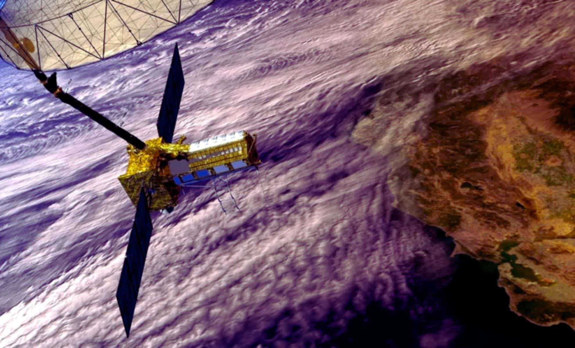
NASA and the Indian Space Research Organisation (ISRO) have teamed up to deploy the NISAR satellite, a state-of-the-art Earth observation system designed to transform our grasp of the planet's surface. Set to blast off on June 18, 2025, from India’s Satish Dhawan Space Centre, this ambitious $1.5 billion mission aims to provide unprecedented data about Earth’s ecosystems, water systems, and natural disasters, capturing details with centimeter-level accuracy regardless of weather or daylight.
Innovative Radar Technology Driving NISAR
The NISAR mission centers on the use of advanced Synthetic Aperture Radar (SAR), a technology that sets it apart from conventional Earth monitoring satellites. Unlike traditional satellites that rely on sunlight reflecting off the surface to capture images, SAR technology actively sends radar waves toward Earth and measures the reflected signals. This allows NISAR to generate clear, high-resolution images regardless of whether it's day or night.
SAR’s ability to penetrate obstructions like clouds, smoke, ash, and dense forests is a key strength, especially valuable in tropical zones and disaster areas affected by floods, wildfires, or volcanic activity. This capability offers detailed insights unobtainable through visible light imaging.


An Unprecedented Partnership: NASA and ISRO’s NISAR Project
This collaboration between NASA and ISRO highlights the synergy of two leading space organizations united to boost global Earth observation. The NISAR satellite will be the first to utilize dual-frequency radar technology, combining two radar bands to achieve remarkably detailed imagery. This innovation will enhance monitoring of forests, wetlands, and water bodies worldwide, reflecting an increasing trend toward international cooperation in space and Earth sciences.
NISAR’s global scanning capabilities will especially benefit hard-to-monitor locations like Antarctica, aiding scientists in analyzing climate change, sea level variations, and shifts in Earth's ice masses even under persistent cloud cover.
Precision Monitoring of Earth’s Surface Changes
NISAR stands out for its remarkable precision, able to detect minuscule shifts in ground elevation measured down to millimeters. This feature is crucial for identifying phenomena such as land subsidence, landslides, and earthquake-induced terrain deformation, providing essential data for disaster preparedness and recovery efforts.
Following earthquakes or volcanic eruptions, NISAR can chart topographical changes in near real-time, delivering vital information to emergency responders. Moreover, it will contribute valuable observations for assessing the condition of natural habitats like forests and wetlands, which are critical for biodiversity and carbon sequestration.
The satellite will update its data every 12 days, furnishing scientists and disaster relief agencies with timely information to better manage environmental hazards and monitor long-term planetary changes linked to climate.
Enhancing Agricultural and Water Resource Management
NISAR will also play a transformative role in agriculture by accurately gauging soil moisture levels through radar measurements. This information is vital for farmers to optimize irrigation strategies, particularly in drought-prone regions, contributing to water conservation, improved crop productivity, and stronger food security.
Besides soil moisture, the satellite will monitor flooding incidents and assess their effects on farmlands. By mapping submerged vegetation and wetland areas, NISAR supports conservation efforts essential for preserving ecosystem health and biodiversity.
Supporting Disaster Response and Environmental Conservation
Natural calamities such as earthquakes, floods, wildfires, and volcanic eruptions can wreak havoc on communities and ecosystems. The NISAR satellite will be essential for producing detailed maps of affected zones and tracking the ongoing environmental impacts, enabling quicker disaster response and more informed decision-making by authorities.
Additionally, its capacity to observe coastal erosion, oil spill distributions, and glacier retreat will aid global environmental monitoring efforts. NISAR's extensive observation capabilities will provide critical data to track the progress of global warming by studying changes in polar ice and glaciers, helping scientists address contemporary climate challenges.
- Categories:
- News


0 comments
Sign in to Comment