

A recent report featured in Science Advances uncovers a growing concern: major urban centers across the U.S. are experiencing accelerated land subsidence. Although the sinking of land isn’t unprecedented, new satellite observations reveal it is occurring at a quicker pace and broader scale than scientists previously anticipated. From dense city blocks in New York City to suburban zones around Houston, the terrain beneath millions of residents is gradually shifting downward, subtly altering the structural fabric of these environments.
Satellite Technology Exposes Hidden Movement of Urban Landscapes
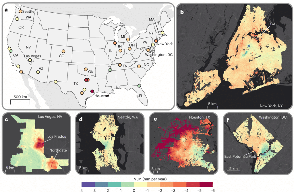
Experts from Columbia University and Virginia Tech utilized satellite radar imaging to capture extremely precise changes in elevation throughout the 28 largest metropolitan areas in the United States. By analyzing time-series radar data, they identified small vertical land shifts measurable to the millimeter.
The study’s findings are striking: at least two-thirds of land area in 25 of the 28 cities studied is undergoing subsidence. In Houston’s case, nearly half the urban expanse is sinking by over five millimeters annually, with 10% of zones experiencing an even faster drop.

Analysis linked approximately 80% of subsidence nationally to excessive withdrawal of groundwater. As aquifers shrink, the soil compresses downward. Leonard Ohenhen, lead author, emphasized that as urban growth encroaches on susceptible terrains, infrastructure faces increasing stress that could exceed its safety thresholds.
New York City’s Widespread but Subtle Decline
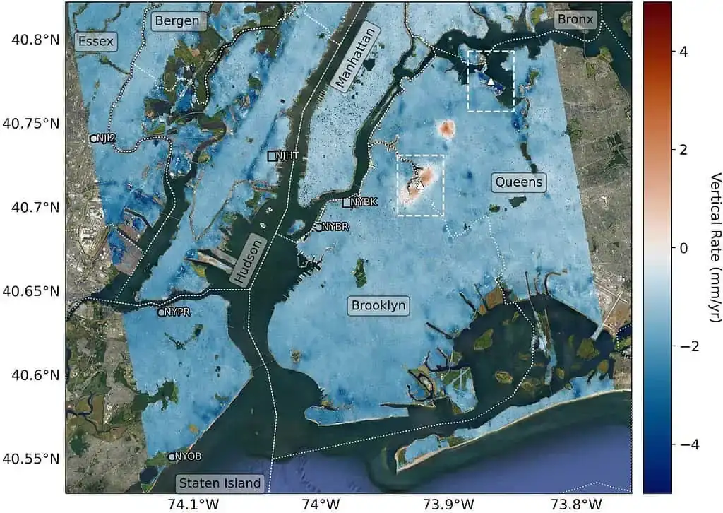
The case of New York City presents unique patterns yet remains alarming. Although long recognized as vulnerable to sinking, recent datasets from NASA, Rutgers, and JPL-Caltech reveal that nearly 98% of NYC’s land is undergoing subsidence. The average yearly descent is about 1.6 millimeters, similar to typical toenail growth.
Employing detailed measurements from Sentinel-1 satellites, scientists mapped the metro area and uncovered variability in sinking rates. For example, LaGuardia Airport’s runway 13/31 is lowering at approximately 3.7 millimeters per year, while Arthur Ashe Stadium, home to the US Open, experiences even faster subsidence at 4.6 millimeters annually. This partly explains the necessity for a lightweight, specially engineered roof design.
Many of these affected sites rest on landfills, composed of loose material more prone to compression than native bedrock. The resultant soil compaction heightens vulnerabilities to flooding and structural integrity issues.
Addressing the Risks in Urban Development
The widespread sinking presents significant challenges for infrastructure. The study identifies over 29,000 buildings in high-risk zones within these metropolitan areas, predicting potential problems like uneven road surfaces, cracked bridges, and buildings settling irregularly if no mitigation occurs.
Researchers advocate that detailed subsidence mapping can inform urban policy and planning. Strategies may include revising construction codes, enhancing stormwater systems, and managing groundwater withdrawals more sustainably. In particularly vulnerable zones, projects to elevate land or implement green infrastructure may reduce further damage.
“This problem is always only going to increase as we progress into the future,” Ohenhen told The Washington Post. The seemingly slow movement beneath cities signals far-reaching consequences ahead.
- Categories:
- News


0 comments
Sign in to Comment