
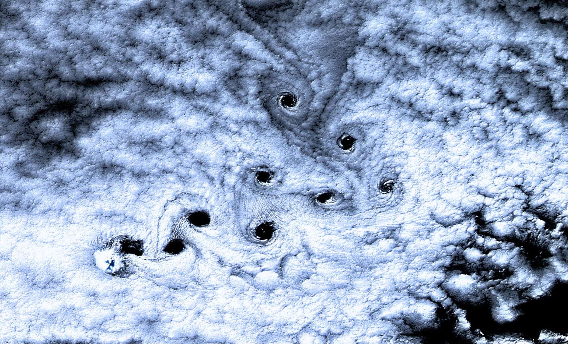
On May 3, 2016, NASA’s Landsat 8 satellite captured an extraordinary high-resolution image showing a series of dark, spinning patterns in the clouds above Heard Island, a secluded volcanic island in the Southern Ocean. Positioned about 1,000 kilometers north of Antarctica, this isolated, uninhabited island gained attention when the image uncovered evenly spaced “holes” disrupting the thick cloud cover.
These formations emerged from natural atmospheric phenomena, specifically von Kármán vortices. These vortices develop when steady winds flow over large obstacles—in this case, Heard Island’s prominent Mawson Peak, an active volcano standing at 2,745 meters. The interaction of the powerful ocean winds, known as the Furious Fifties, with the volcano altered airflow patterns, generating repeating rotating eddies. According to NASA’s Earth Observatory, “the alternating vortices trail downwind in a sequence that reflects the laws of fluid dynamics.”
What Makes These Cloud Spirals So Striking
While von Kármán vortex streets have been documented previously, the formation over Heard Island stood out due to its exceptional sharpness and contrast. The spirals appeared as dark gaps rather than faint cloud swirls, thanks to a dense and uniform cloud layer that provided an ideal backdrop. Inside each vortex, the turbulent rotation thinned or entirely cleared the cloud cover, creating distinctive dark, eye-like shapes prominently visible to satellite sensors.

NASA researchers also noted that the lighting conditions enhanced the image’s clarity. The low angle of sunlight during the Southern Hemisphere’s early autumn cast shadows that intensified the darkness within the cleared cloud patches. As a result, these vortices not only disturbed the clouds but temporarily erased them, producing a dramatic visual effect.
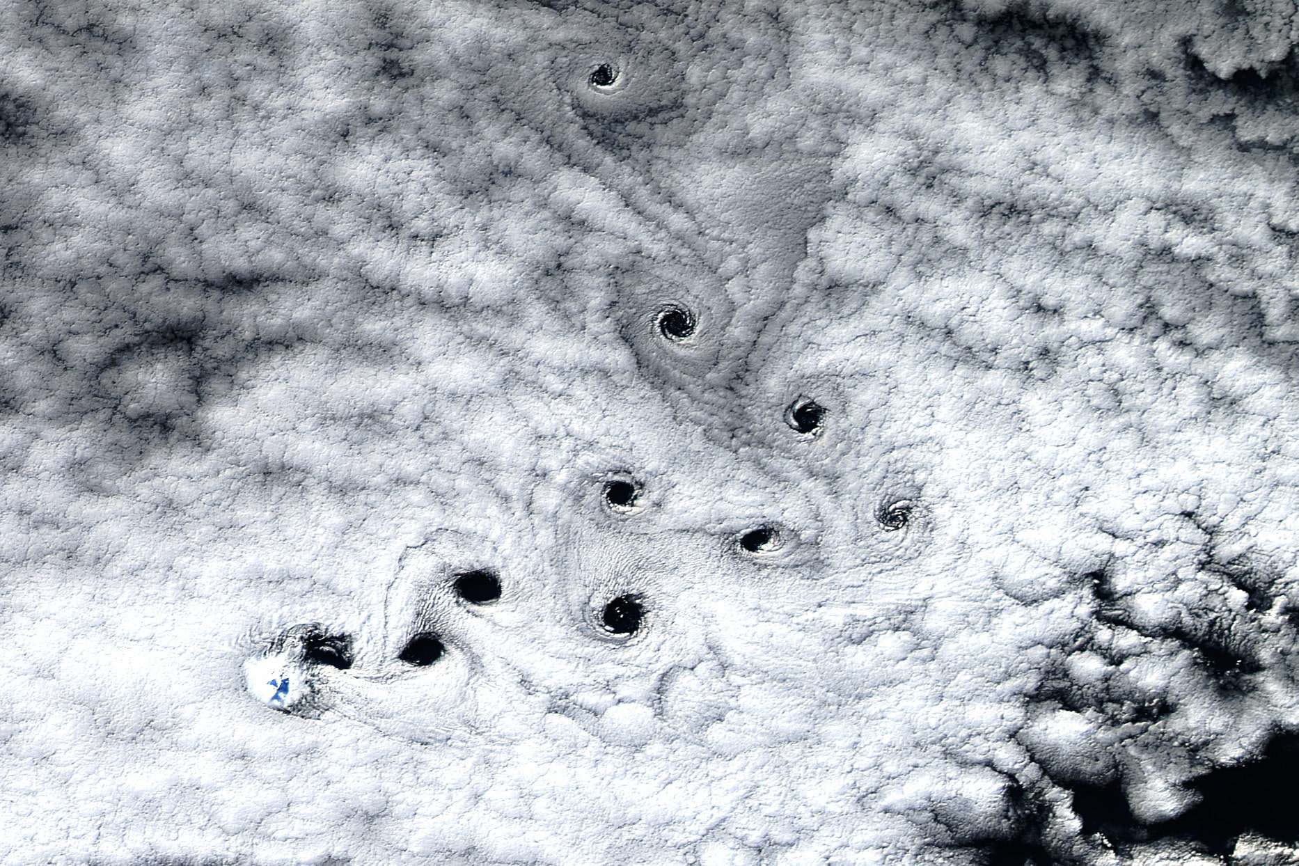
Adding further intrigue, the vortex street exhibits a distinctive 90-degree bend mid-sequence. Atmospheric experts suggest this curvature likely resulted from variations in wind direction or velocity at different heights, gently steering the airflow while maintaining the vortex pattern.
A Unique Hub for Atmospheric Studies
Due to its remote location and elevated terrain, Heard Island serves as an excellent natural observation point for pristine atmospheric events. It acts as a natural experimental site where researchers can examine how landforms affect oceanic and atmospheric systems. Free from human pollution or disturbances, satellite images from the region often reveal some of the most clear and vivid examples of atmospheric dynamics.
The role of Mawson Peak is pivotal. Towering directly from the ocean, the volcano consistently influences airflow across the island. When strong westerly winds surge over its summit, they form distinct aerodynamic patterns usually disrupted in more complex or populated environments. This consistency makes Heard Island one of the most remarkable vortex-producing locations observable from space.
Cloud Patterns as Tools for Weather Insights
Beyond their visual appeal, von Kármán vortex streets provide valuable data for meteorological and climate analyses. Their form and spacing reveal details about atmospheric pressure, wind velocity, and turbulence intensity. Scientists studying the remote Southern Hemisphere use these vortex streets to gain insight into airflow dynamics where direct ground measurements are scarce.
As NASA highlights, analyzing vortices like those over Heard Island aids in refining global climate and weather models, improving predictions of long-term patterns. These formations also enhance satellite-based wind measurement techniques, supplying more accurate data essential for aviation, weather forecasting, and climate monitoring.
- Categories:
- News


0 comments
Sign in to Comment