
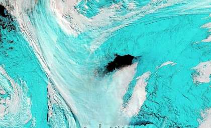
A groundbreaking scientific atlas has transformed our understanding of Antarctica’s seafloor, unveiling hidden features that could reshape how scientists predict sea-level rise, ocean currents, and the continent’s geological evolution. This research, featured in Marine Geology, was spearheaded by teams from the University of Barcelona and University College Cork, revealing an astonishing 332 newly identified submarine canyons beneath Antarctica’s margin—quintupling prior estimates.
This vast network of deep canyons provides unprecedented insights into the interactions between glacial ice sheets and oceanic processes over geological time, offering vital clues on how these forces drive contemporary global climate regulation.
Charting Antarctica’s Hidden Underwater Terrain
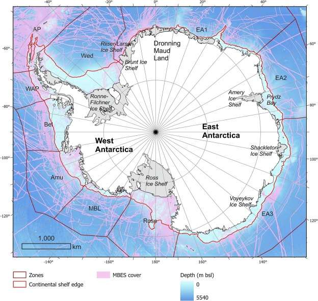
The researchers integrated high-resolution bathymetric measurements from more than 40 global missions to develop the first comprehensive, consistent map of Antarctica’s submerged canyon systems. The technical difficulty of acquiring sonar data beneath floating ice shelves and remote ocean expanses had previously concealed many of these geographic features.

Several of the mapped canyons reach depths exceeding 4,000 meters, serving as essential underwater channels that transport sediments, nutrients, and water masses from the continental shelf to the deep sea. Scientists note their immense size and intricacy rival some of the Earth’s most prominent submarine canyon systems.
“For the first time, we have a unified perspective of these canyon systems spanning the entire Antarctic continental margin,” explained Dr. David Amblàs of the University of Barcelona. “Their distribution isn’t random; they’re intricately linked to ice dynamics across time.”
Contrasting Landscapes: East Versus West Antarctica
The findings reveal pronounced differences between East and West Antarctica, insights critical for interpreting their distinct responses to historical climate fluctuations. The eastern sector features widespread, branching canyon networks formed by numerous tributaries, indicative of long-term stability under steady ice sheet conditions.
Conversely, the western margin displays canyons that are generally steeper, shorter, and straighter, signaling more recent, intermittent glacial activity. These structural traits correlate with current models that show West Antarctica experiencing greater ice movement and heightened vulnerability to rapid melting.
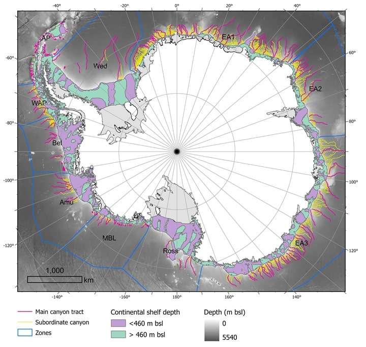
Dr. Alan Condron from Woods Hole Oceanographic Institution, a co-author of the paper, noted that these structural contrasts enhance scientists’ abilities to “reconstruct ice flow patterns” and refine predictions on how these ice masses might evolve as temperatures rise.
Submarine Canyons’ Critical Role in Ocean Circulation
Beyond their geological significance, these undersea canyons play a vital role in regulating Antarctic water circulation. They act as pathways that guide cold, saline water formed on the continental shelf into the deep Southern Ocean, fueling thermohaline circulation—a global conveyor belt that influences ocean temperature and nutrient transport worldwide.
However, this exchange operates in both directions; warmer deep water can ascend through the canyons, reaching beneath ice shelves and intensifying basal melting. This upward movement is a pivotal driver in the ice shelf destabilization observed especially in West Antarctica.
“Water movement through these canyons is central, not incidental, to how heat penetrates the ice and how fresh meltwater disperses,” explained Dr. Condron.
Enhancing Climate Models with Detailed Seafloor Data
As climate models increasingly emphasize regional-scale dynamics, integrating these newly uncovered canyon networks fills a crucial knowledge gap. Previously, many simulations treated Antarctica’s seabed as relatively smooth, overlooking the impact of submarine topography on ocean currents, sediment transport, and ice-ocean interactions.
With this detailed bathymetric framework, scientists can now incorporate canyon morphology and connectivity into models, improving forecasts of ice loss progression and its contribution to global sea-level rise.
The research team emphasizes that understanding these canyon systems is more than a historical exercise: they could determine the pace at which melting glaciers discharge water into the ocean, with profound implications for vulnerable coastal communities and marine ecosystems around the globe.
- Categories:
- Science


0 comments
Sign in to Comment