

Tropical Storm Ernesto is swiftly closing in on Puerto Rico, carrying threats of intense rainfall, flooding events, and strong winds. This storm is part of a notably busy hurricane season that weather experts are monitoring closely.
The National Hurricane Center reports that Ernesto is set to grow stronger as it traverses the Caribbean Sea, presenting substantial risks to Puerto Rico and nearby islands.
As the storm is predicted to intensify in the coming days, communities and authorities are preparing for what could turn out to be one of this season's major meteorological challenges.

Development and Movement of Tropical Storm Ernesto
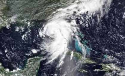
The birth of Tropical Storm Ernesto started with scattered showers and thunderstorms a few hundred miles east of the Leeward Islands. By Monday, these weather patterns began to organize, and by early Tuesday, Ernesto is anticipated to reach tropical storm status.
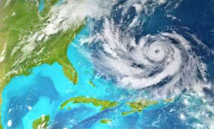
In contrast to the earlier Tropical Storm Debby, which headed toward the U.S. mainland, Ernesto is forecasted to turn northward as it gains strength, potentially evolving into a hurricane as it passes over the warm Atlantic waters. This shifting path might eventually put Bermuda at risk later this week, although exact details remain uncertain.
By Monday night, the National Hurricane Center had issued tropical storm alerts across a wide region including the Leeward Islands, the US and British Virgin Islands, and Puerto Rico. These advisories indicate expected tropical storm conditions, with sustained winds reaching near 73 mph and stronger gusts likely.
Such winds have the potential to inflict notable structural damage, including uprooting trees and bringing down power lines, which could result in widespread electricity outages. The situation remains dynamic, with additional warnings and watches possible as the storm's trajectory becomes clearer.

Risks from Rain and Flooding
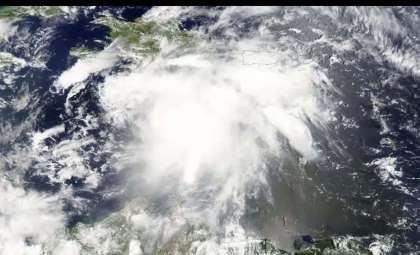
A primary danger associated with Tropical Storm Ernesto lies in the heavy rain it is predicted to deliver across the region. Forecasters estimate broad rainfall accumulations between 4 to 6 inches over the eastern and northern Caribbean, with parts of Puerto Rico possibly experiencing up to 10 inches. This volume of rain could trigger flash floods and landslides, especially in vulnerable terrain. The National Hurricane Center has cautioned that “heavy rainfall may result in locally considerable flash flooding and mudslides,” underscoring the seriousness of the threat.
The timing of these precipitation events plays a crucial role. Heaviest rain is forecasted from late Monday through Wednesday over the Leeward Islands, while Puerto Rico is expected to endure the heaviest downpours between Tuesday and Thursday. This extended rainy period combined with strong winds might further stress Puerto Rico's infrastructure, particularly its fragile electrical grid. The island’s power systems, still vulnerable from damage caused by past hurricanes, could face substantial challenges should Ernesto hit with the anticipated intensity.
Forecasted Strengthening and Subsequent Effects
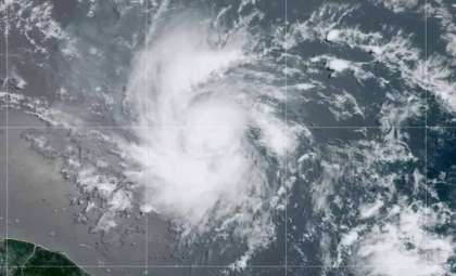
As Tropical Storm Ernesto moves across the Caribbean, experts are monitoring its potential for further strengthening. Modeling indicates that by Wednesday, Ernesto will begin turning northward, moving away from the Caribbean islands and into the open Atlantic Ocean. There, it is predicted to gain strength considerably, with a chance of escalating to a major hurricane—possibly Category 3 or stronger—by later in the week.
The storm’s intensity and path depend on multiple key influences, including ocean temperatures, which supply energy for intensification, and upper-level winds, which could either facilitate development or hinder it. A delayed northward shift might bring Ernesto closer to landmasses like Hispaniola or the southern Bahamas, increasing exposure in those regions.
Even if Ernesto stays over open waters, its impact will be widespread. Dangerous seas and rip currents are expected to affect the US East Coast, the Bahamas, and various Caribbean locations into early next week. These conditions pose significant risks to marine activities and coastal communities, regardless of whether the storm makes landfall.
Residents in vulnerable zones are strongly encouraged to remain updated and take precautionary measures. Rapid intensification is possible, making preparedness essential to ensure safety during this potentially severe weather event.
- Categories:
- News ,
- Climate change


0 comments
Sign in to Comment